综合:南加四场山火全部受控推进 Henderson控制率升至50% Norte疏散令全解
南加州本周四场主要山火,截至10月17日晚全部处于受控推进状态,无一失控扩散。据加州消防局(CAL FIRE)官方事件数据,四场火合计过火约3,920英亩:San Diego County彭德尔顿营(Camp Pendleton)的「Henderson Fire」3,160英亩、控制率50%;Orange County的「Norte Fire」570英亩、控制率25%;洛杉矶县Malibu的「Bryson Fire」146.2英亩、控制率61%;洛杉矶县Azusa的「Peak Fire」43.3英亩、控制率41%。四场火的面积近一日均基本稳定,控制率则全部较此前上升;疏散方面,Norte与Bryson两场火的疏散令已于17日全部解除,Henderson的基地疏散令早前已解除,Peak的疏散令此前已降级为警告。各场火详情如下。
最大的一场是彭德尔顿营「Henderson Fire」。它位于基地西侧Henderson Street与Brown Street交口附近,10月15日下午2时35分燃起。CAL FIRE官方事件数据17日晚7时24分更新:过火面积3,160英亩,控制率由20%大幅升至50%,是这场火燃起以来的最大单日进展;面积较今晨仅增加28英亩,火场周界已基本稳定。疏散方面,基地41区(Las Flores)的疏散令已于15日晚解除,基地外周边社区自始至终未下达疏散令,临时疏散点仍设在11区的Paige Field House与21区健身中心。官方至今未报告建筑损毁或人员伤亡,起火原因仍在调查中。因火势与浓烟两度双向关闭的I-5州际公路已于16日下午全线重开,最新官方数据未再提及新的关闭安排。下一步,San Diego County事故管理团队正支援火场,消防员继续构筑控制线、扑灭热点。
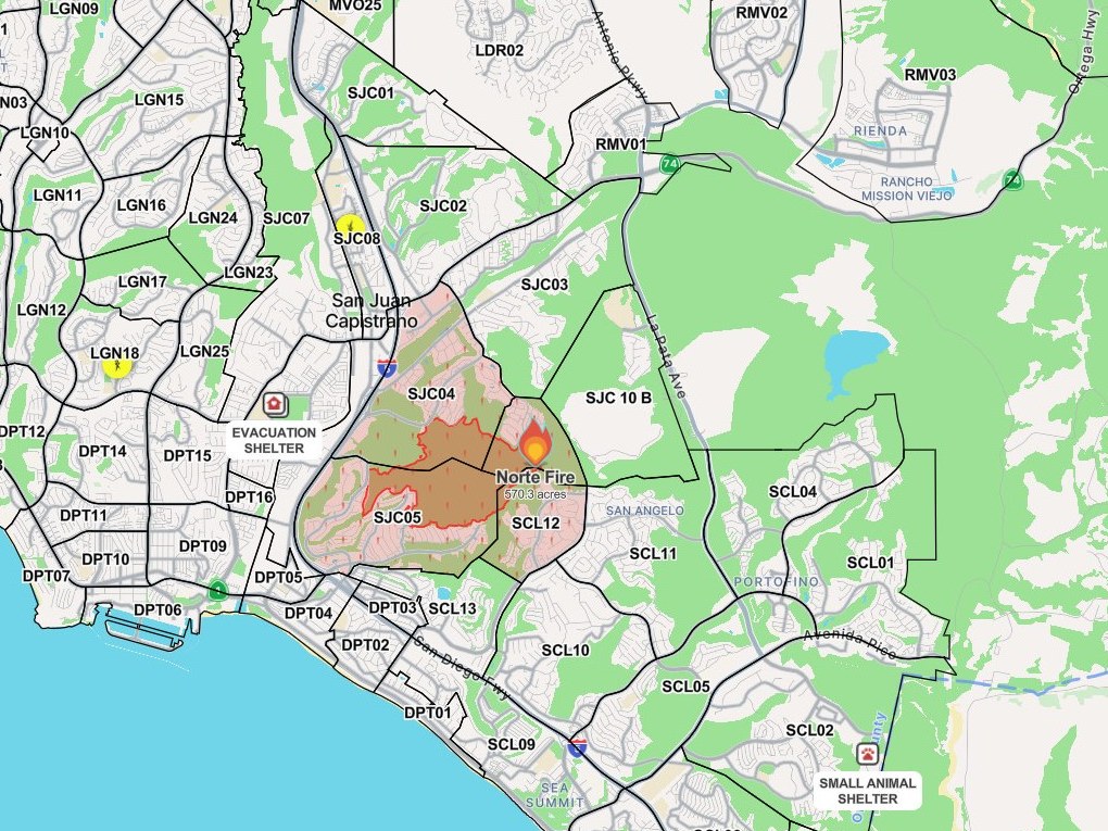
对居民影响最直接的是Orange County「Norte Fire」。它位于San Clemente的Portico Del Norte与Eminencia Del Norte一带,10月16日上午11时33分燃起,由Orange County消防局(OCFA)主管扑救。CAL FIRE官方数据17日晚10时14分更新:过火面积570英亩、控制率25%,与傍晚通报一致。17日晚6时起,San Clemente与San Juan Capistrano两市此前生效的疏散令全部解除,包括最后四个分区SJC04、SJC05、SJC10-A与SCL12,居民可返回家中;这场火在高峰时曾令约1.6万名居民处于疏散令之下,共有6栋房屋受损或被毁、2名消防员受伤送院且情况稳定。需要注意的是,Via La Mirada Esperanza以北区域及火烧痕迹区仍然封闭。加州已为这场山火争取到联邦紧急事务管理局(FEMA)的消防援助拨款,联邦将报销75%的灭火开支。下一步,消防员将在火场周界内继续巡查、处置烟点与热点。
洛杉矶县Malibu的「Bryson Fire」位于Encinal Canyon Road一带,10月15日晚燃起。CAL FIRE官方数据17日晚6时23分更新:过火面积146.2英亩,控制率升至61%,为四场火中最高。洛杉矶县警长局(LASD)17日晚通报,这场火的全部疏散令与疏散警告已经解除,其中两个分区降为提示状态;所有因火封闭的道路已重新开放,包括Topanga Canyon Boulevard,设在Agoura High School的居民庇护点与Pierce College的大型动物庇护点均已关闭,原定的预防性停电也正取消。国家气象局(NWS)针对洛杉矶县的红旗警告已于17日晚6时到期。官方通报这场火没有造成建筑损毁或损坏。下一步,消防员在146英亩火场范围内继续扑灭余火,向全面控制推进。
四场中最小的是洛杉矶县Azusa的「Peak Fire」,位于San Gabriel Canyon Road与Mirador Drive以北,10月15日晚燃起。CAL FIRE官方数据17日上午8时55分的更新仍为:过火面积43.3英亩、控制率41%,与15日测绘修正后的数字相同,两日来没有变化,火势保持稳定。此前针对AZU-MC01分区的疏散令已降级为疏散警告。下一步,消防员继续在火场内作业,推进至全面控制。
总览四场:截至17日晚,南加四场山火无一失控,扑救重点已由阻截扩散转入巩固控制线与清理热点阶段;四场火均尚未完全扑灭,后续控制率与余火处置进展,本站将继续跟进。
Roundup: All Four Southern California Wildfires Moving Toward Containment — Henderson at 50%, Norte Evacuations Fully Lifted
All four major wildfires burning in Southern California this week were moving toward containment as of Saturday evening, October 17, with none out of control, according to CAL FIRE's official incident data. Together they have burned about 3,920 acres: the Henderson Fire at Marine Corps Base Camp Pendleton in San Diego County, at 3,160 acres and 50% contained; the Norte Fire in Orange County, at 570 acres and 25% contained; the Bryson Fire in Malibu, Los Angeles County, at 146.2 acres and 61% contained; and the Peak Fire in Azusa, Los Angeles County, at 43.3 acres and 41% contained. Acreage has largely stabilized over the past day while containment has risen on all four fires. Evacuation orders for the Norte and Bryson fires were fully lifted on Saturday, the Henderson Fire's on-base order was lifted earlier, and the Peak Fire's order had previously been downgraded to a warning. Details on each fire follow.
The largest is the Henderson Fire at Camp Pendleton, which began at 2:35 p.m. on October 15 near Henderson Street and Brown Street on the base's west side. CAL FIRE's incident data, updated at 7:24 p.m. on October 17, put it at 3,160 acres with containment jumping from 20% to 50% — the largest single-day gain since the fire began — while acreage rose by just 28 acres from the morning figure, indicating the perimeter has largely stabilized. The evacuation order for the base's Las Flores (41 Area) was lifted on the evening of October 15, no evacuation orders were ever issued for surrounding off-base communities, and temporary evacuation points remain at the Paige Field House in the 11 Area and the 21 Area Fitness Center. Officials still report no structures damaged and no injuries, and the cause remains under investigation. Interstate 5, twice closed in both directions because of flames and smoke, fully reopened on the afternoon of October 16, and the latest official data mentioned no new closure. Next, the San Diego County Incident Management Team is supporting the incident as firefighters continue building containment lines and extinguishing hot spots.
The fire with the most direct impact on residents is the Norte Fire in Orange County, which began at 11:33 a.m. on October 16 near Portico Del Norte and Eminencia Del Norte in San Clemente, under the command of the Orange County Fire Authority (OCFA). CAL FIRE data updated at 10:14 p.m. on October 17 held it at 570 acres and 25% contained, unchanged from the evening briefing. As of 6 p.m. on October 17, all evacuation orders in San Clemente and San Juan Capistrano were lifted, including the last four zones — SJC04, SJC05, SJC10-A and SCL12 — and residents may return home. At its peak the fire placed roughly 16,000 residents under evacuation orders; six homes were damaged or destroyed and two firefighters were taken to a hospital in stable condition. The area north of Via La Mirada Esperanza and the burn scar remain closed. California has secured a federal Fire Management Assistance Grant from FEMA for this fire, with the federal government reimbursing 75% of suppression costs. Next, firefighters will continue patrolling the perimeter and addressing smoke and hot spots inside it.
The Bryson Fire in Malibu, Los Angeles County, burning near Encinal Canyon Road since the night of October 15, stood at 146.2 acres and 61% contained — the highest containment of the four — in CAL FIRE data updated at 6:23 p.m. on October 17. The Los Angeles County Sheriff's Department announced Saturday evening that all evacuation orders and warnings for this fire have been lifted, with two zones downgraded to advisory status. All roads closed by the fire have reopened, including Topanga Canyon Boulevard; the resident shelter at Agoura High School and the large-animal shelter at Pierce College have closed, and planned precautionary power shutoffs are being canceled. The National Weather Service's red flag warning for Los Angeles County expired at 6 p.m. on October 17. Officials report no structures were damaged or destroyed by this fire. Next, firefighters continue mopping up hot spots across the 146-acre fire area toward full containment.
The smallest of the four is the Peak Fire in Azusa, Los Angeles County, north of San Gabriel Canyon Road and Mirador Drive, which began on the night of October 15. CAL FIRE's update at 8:55 a.m. on October 17 still listed it at 43.3 acres and 41% contained — the same figures produced by a mapping revision on October 15, unchanged for two days, with the fire holding stable. The evacuation order for zone AZU-MC01 was previously downgraded to an evacuation warning. Next, crews continue working inside the fire area toward full containment.
In summary, as of Saturday evening none of the four Southern California fires was out of control, and suppression has shifted from stopping spread to strengthening containment lines and mopping up hot spots. None of the four is fully out yet; this newsroom will continue to follow containment and mop-up progress.
来源:GSM·美国(原文链接)
图片来源:图:Norte Fire 火场周界与疏散分区态势图,Watch Duty 截图(10月17日18时16分截取)。图中标注的570.3英亩为截取时数据;四场山火最新数字以正文所引加州消防局(CAL FIRE)官方事件数据为准。图片来源:Watch Duty。Situation map of the Norte Fire perimeter and evacuation zones, Watch Duty screenshot taken at 6:16 p.m. on Oct. 17. The 570.3 acres shown reflects mapping at capture time; the latest figures for all four fires in the text are from CAL FIRE's official incident data. Source: Watch Duty.
GSM Global · 本篇英文版 English edition of this story
- 2026-10-15 14:45阿祖萨「Peak Fire」烧至22英亩 疏散令生效 直升机投水护房
- 2026-10-15 14:53San Diego County彭德尔顿营「Henderson Fire」烧至约75英亩 浓烟升腾 控制率尚未公布
- 2026-10-15 15:52跟进:阿祖萨「Peak Fire」扩至约60英亩 AZU-MC01疏散令降级为警告
- 2026-10-15 16:17跟进:彭德尔顿营「Henderson Fire」扩至约150英亩 基地外仍无疏散令
- 2026-10-15 18:18洛县Malibu「Bryson Fire」扩至至少40英亩 KAN-U017分区发布疏散令
- 2026-10-15 18:32跟进:阿祖萨「Peak Fire」测绘修正为43英亩 控制率升至41%
- 2026-10-15 18:44跟进:Malibu「Bryson Fire」扩至80英亩 疏散警告增至10个分区
- 2026-10-15 18:51跟进:彭德尔顿营「Henderson Fire」测绘周界约1,117英亩 41区疏散令下达、I-5一度关闭后重开
- 2026-10-15 22:17跟进:Malibu「Bryson Fire」据报扩至约200英亩 红十字会在阿古拉高中开设避难所
- 2026-10-16 13:51跟进:彭德尔顿营「Henderson Fire」扩至2,080英亩仍零控制 I-5在Vandegrift至Basilone段双向关闭
- 2026-10-16 14:45Orange County「Norte Fire」烧至250英亩 San Juan Capistrano与San Clemente多区疏散、4栋房屋受波及
- 2026-10-16 15:08跟进:Orange County「Norte Fire」扩至465英亩仍未控制 现场报道至少8栋建筑被烧
- 2026-10-16 19:51跟进:加州为Orange County Norte Fire 争取到联邦消防援助拨款 联邦报销75%灭火开支
- 2026-10-16 20:50跟进:Norte Fire疏散区开设过夜庇护所 消防官员称2名消防员受伤送院、情况稳定
- 2026-10-16 20:50跟进:Malibu「Bryson Fire」控制率升至39% 过火面积测绘修正为146.2英亩
- 2026-10-16 21:29跟进:Orange County「Norte Fire」面积修订为570英亩 仍未控制 疏散令维持不变
- 2026-10-17 00:57跟进:Orange CountyNorte Fire过火面积570英亩、控制率仍为0% 6栋房屋受损、约1.6万人仍在疏散令下
- 2026-10-17 01:16跟进:彭德尔顿营「Henderson Fire」控制率升至20% 过火2,079英亩 I-5全线重开
- 2026-10-17 09:19跟进:彭德尔顿营「Henderson Fire」过火面积上修至3,132英亩 控制率仍为20%
- 2026-10-17 09:19跟进:Malibu「Bryson Fire」控制率升至52% 过火面积仍约147英亩
- 2026-10-17 10:01跟进:Orange County「Norte Fire」出现首个控制率 过火570英亩、控制率升至5% 疏散令维持
- 2026-10-17 13:54跟进:Orange County「Norte Fire」首批疏散令解除 San ClementeSCL13区、San Juan CapistranoSJC10-B区居民可返家
- 2026-10-17 18:16跟进:Orange County「Norte Fire」控制率升至25% 过火面积仍为570英亩 四个分区疏散令维持
- 2026-10-17 18:41跟进:Orange County「Norte Fire」疏散令全部解除 San Clemente与San Juan Capistrano居民可返家
- 2026-10-17 19:21跟进:Malibu「Bryson Fire」疏散令与警告全部解除 道路重开 两处庇护点关闭
- 2026-10-17 22:34跟进:彭德尔顿营「Henderson Fire」控制率升至50% 过火面积3,160英亩
- 2026-10-17 22:40综合:南加四场山火全部受控推进 Henderson控制率升至50% Norte疏散令全解本篇
- 2026-10-18 08:41跟进:San Clemente市经理就Norte山火宣布本地紧急状态 紧急令10月24日到期待市议会追认
- 2026-10-18 12:25跟进:Malibu「Bryson Fire」控制率升至68% 过火面积仍约147英亩
- 2026-10-18 14:15跟进:Norte山火控制率升至50% Capistrano学区周一全面复课
- 2026-10-18 16:24跟进:彭德尔顿营「Henderson Fire」控制率升至65% 消防员转入清场灭余火
- 2026-10-18 22:51跟进:Malibu「Bryson Fire」控制率升至74% 过火面积仍约147英亩
- 2026-10-18 23:28跟进:Orange County「Norte Fire」控制率升至60% 过火面积仍为570英亩
- 2026-10-19 08:11跟进:彭德尔顿营「Henderson Fire」控制率升至95% 过火面积经精确测绘修订为3,260英亩
- 2026-10-19 08:29跟进:Malibu「Bryson Fire」控制率升至83% 过火面积仍为147英亩
- 2026-10-19 11:46跟进:Orange County「Norte Fire」控制率升至75% 过火面积仍为570英亩
- 2026-10-19 18:30跟进:Orange County「Norte Fire」控制率升至80% 过火面积仍为570英亩
- 2026-10-19 21:02跟进:彭德尔顿营「Henderson Fire」达到100%控制 过火面积3,260英亩
- 2026-10-20 10:23跟进:Malibu「Bryson Fire」已全面控制 过火面积约146英亩
- 2026-10-20 15:47跟进:Orange County「Norte Fire」控制率升至90% 过火面积仍为570英亩