跟进:彭德尔顿营「Henderson Fire」测绘周界约1,117英亩 41区疏散令下达、I-5一度关闭后重开
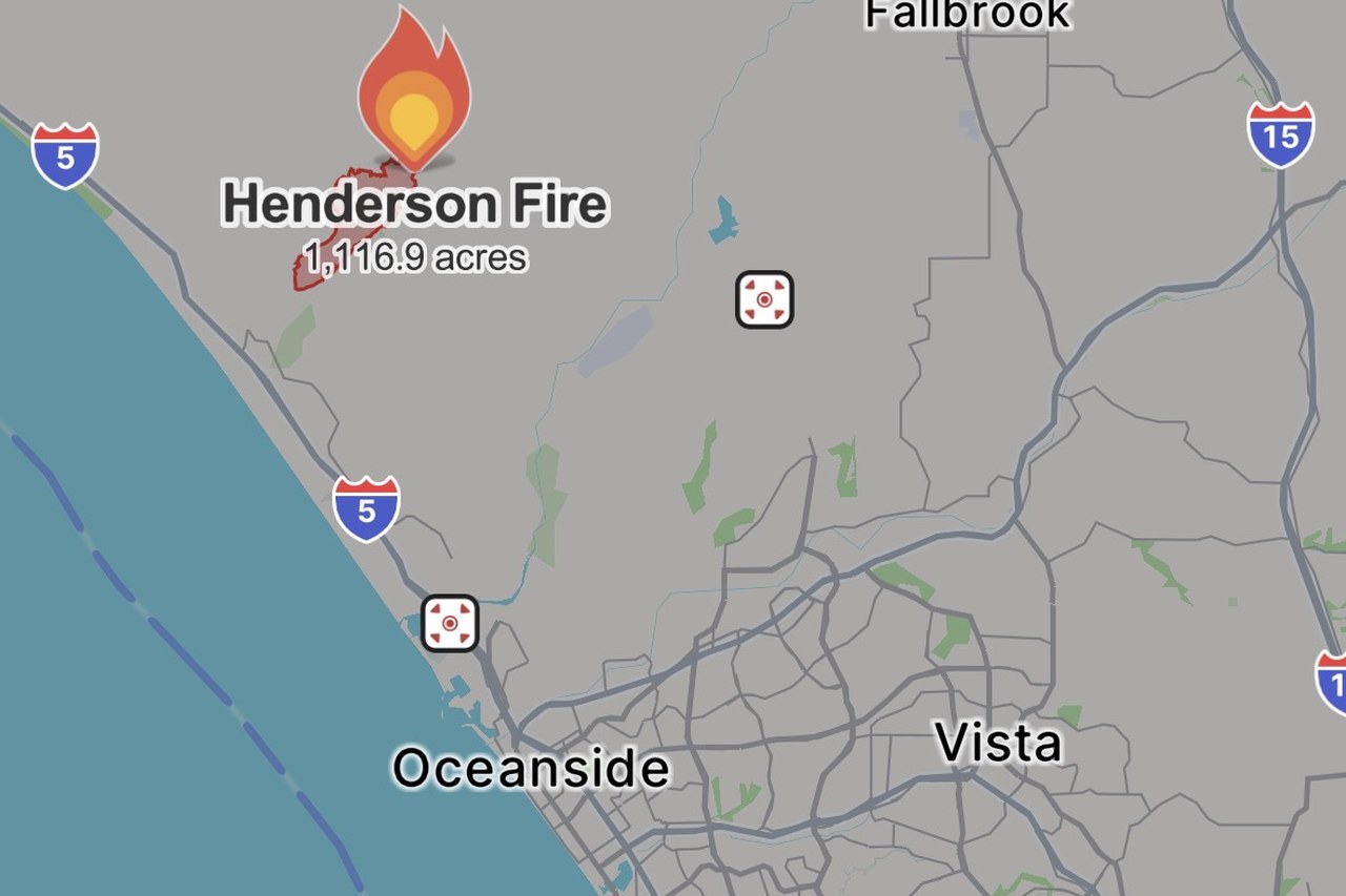
彭德尔顿营(Camp Pendleton)——10月15日下午在San Diego County海军陆战队彭德尔顿营燃起的灌木野火「Henderson Fire」傍晚继续扩大,基地再对一区下达疏散令,5号州际公路(I-5)一度双向关闭。面积方面目前有两个口径:加州消防局(Cal Fire)事件页下午3时25分的文字更新称,火场经空中测算为400英亩;傍晚,火灾追踪平台Watch Duty采用的官方测绘数据(源自联邦跨部门野火地理数据库)显示,这场火的测绘周界面积约为1,117英亩,San DiegoNBC 7电视台当晚亦报道火场已达至少1,117英亩。两个数字中,前者是下午的空中估算,后者是其后绘制的火场周界所含面积;截至发稿,现场指挥部尚未发布新的核定过火面积,控制率亦未公布。本报上一篇跟进稿(下午4时20分)报道的面积约为150英亩。
疏散方面,据Cal Fire事件页,基地于下午5时13分对拉斯弗洛雷斯(Las Flores,即41区)发布疏散令,受影响人员前往11区的Paige Field House安置;下午5时26分,据基地脸书页面,21区体育馆增设为第二疏散点。此前基地内已发布的疏散令仍然有效,截至发稿,官方未发布解除通报。43区(Las Pulgas一带)的停电仍在持续,未见恢复供电的通报。基地之外,截至发稿,Oceanside等周边社区仍未发布疏散令或疏散警告;北县多个社区另有烟雾提示(据当地电视台报道)。
道路方面,Cal Fire下午4时11分就这场火发布「威胁I-5」警示;下午5时09分,事件指挥官表示,I-5将在Harbor Drive至Basilone Road之间双向关闭;加州公路巡警(CHP)通报,关闭于5时37分生效;至5时49分,CHP称I-5全面重开正在进行,但如情况需要可能再次关闭。基地内Las Pulgas路(Brown Street至Stuart Mesa Road段)与Las Pulgas大门仍处于关闭状态。
扑救方面,基地消防部门与Cal Fire等机构持续作业,下午一度有4架灭火飞机参与,火场上方的建筑与电线仍受威胁。截至发稿,官方未通报人员伤亡;截至下午3时30分,官方称尚无建筑损毁报告,此后未见新的损毁通报。起火原因仍在调查中。
前情回顾:这场火于当日下午2时许在基地西部Henderson Street与Brown Street交叉口附近燃起,Cal Fire下午2时39分登记为10英亩,在东风推动下迅速扩大——2时43分约75英亩、2时47分100英亩、2时52分估算为100至150英亩、3时25分经空中测算达400英亩。火场位于基地43区一带,起火后不久,基地即对相关区域发布疏散令,Las Pulgas一带出现停电。本报首发与第一篇跟进稿已报道起火及扩至约150英亩的经过,本篇为同一事件线的第二篇跟进。
(资料来源:Cal Fire「Henderson Fire」事件页(更新至10月15日17:49);Watch Duty态势图及测绘数据;NBC 7San Diego;City News Service)
Follow-Up: Camp Pendleton Henderson Fire Mapped at About 1,117 Acres; 41 Area Evacuation Ordered, I-5 Closed and Reopened
CAMP PENDLETON — The Henderson Fire, a brush fire that broke out on the afternoon of October 15 at Marine Corps Base Camp Pendleton in San Diego County, kept growing into the evening, prompting a new evacuation order on base and a temporary full closure of Interstate 5. Two size figures are in circulation, on different bases: Cal Fire's incident page, in a 3:25 p.m. text update, put the fire at 400 acres as measured from the air; by evening, official mapping data carried by the fire-tracking platform Watch Duty, sourced from the federal interagency wildfire geospatial database, showed a mapped fire perimeter of about 1,117 acres, and NBC 7 San Diego likewise reported that the fire had reached at least 1,117 acres. The first figure is an afternoon aerial estimate; the second is the acreage inside the subsequently mapped perimeter. As of publication, incident command had not released a revised confirmed burned acreage, and no containment figure has been announced. GSM's previous follow-up, published at 4:20 p.m., reported about 150 acres.
According to Cal Fire's incident page, at 5:13 p.m. the base issued an evacuation order for Las Flores (the 41 Area), directing affected personnel to evacuate to Paige Field House in the 11 Area; at 5:26 p.m., a secondary evacuation point was established at the 21 Area gym, according to the base's Facebook page. Evacuation orders issued earlier for areas on base remain in effect, and officials had issued no notice lifting them as of publication. The power outage around Las Pulgas (the 43 Area) continues, with no restoration notice issued. Outside the base, no evacuation orders or warnings had been issued for surrounding communities such as Oceanside as of publication; a smoke advisory is in effect for North County communities, according to local television reports.
Cal Fire issued a "threat to Interstate 5" alert for the fire at 4:11 p.m. At 5:09 p.m. the incident commander said I-5 would close in both directions between Harbor Drive and Basilone Road; the California Highway Patrol said the closure was in effect at 5:37 p.m., and at 5:49 p.m. CHP said the full reopening of I-5 was under way, though the highway may be closed again immediately if conditions require. Las Pulgas Road, between Brown Street and Stuart Mesa Road, and the Las Pulgas Gate remain closed.
Camp Pendleton firefighters, Cal Fire and assisting agencies continue the attack; four air tankers were assigned in the afternoon, and structures and power lines above the fire remain threatened. As of publication, officials had reported no injuries; as of 3:30 p.m. there were no reported structural damage, and no further damage reports have been issued since. The cause of the fire remains under investigation.
Background: the fire was reported shortly before 2 p.m. near Henderson Street and Brown Street in the western part of the base. Cal Fire logged it at 10 acres at 2:39 p.m., and east winds pushed it to about 75 acres by 2:43 p.m., 100 acres by 2:47 p.m., an estimated 100 to 150 acres by 2:52 p.m., and 400 acres by aerial measurement at 3:25 p.m. The fire is burning around the base's 43 Area; the base ordered evacuations for affected areas soon after it started, and an outage was reported in the Las Pulgas area. GSM's first report and first follow-up covered the ignition and the growth to about 150 acres; this is the second follow-up on the same incident thread.
(Sources: Cal Fire Henderson Fire incident page, updated through 5:49 p.m. Oct. 15; Watch Duty situation map and mapping data; NBC 7 San Diego; City News Service)
来源:GSM·美国(原文链接)
图片来源:图片来源:Henderson Fire态势图,Watch Duty截图,10月15日18:44左右;图中火场周界与面积为该平台采用的官方测绘数据。Situation map of the Henderson Fire, screenshot from Watch Duty at about 6:44 p.m. on Oct. 15; the perimeter and acreage shown reflect official mapping data carried by the platform.
GSM Global · 本篇英文版 English edition of this story
- 2026-10-15 14:53San Diego County彭德尔顿营「Henderson Fire」烧至约75英亩 浓烟升腾 控制率尚未公布
- 2026-10-15 16:17跟进:彭德尔顿营「Henderson Fire」扩至约150英亩 基地外仍无疏散令
- 2026-10-15 18:51跟进:彭德尔顿营「Henderson Fire」测绘周界约1,117英亩 41区疏散令下达、I-5一度关闭后重开本篇
- 2026-10-16 13:51跟进:彭德尔顿营「Henderson Fire」扩至2,080英亩仍零控制 I-5在Vandegrift至Basilone段双向关闭
- 2026-10-17 01:16跟进:彭德尔顿营「Henderson Fire」控制率升至20% 过火2,079英亩 I-5全线重开
- 2026-10-17 09:19跟进:彭德尔顿营「Henderson Fire」过火面积上修至3,132英亩 控制率仍为20%
- 2026-10-17 22:34跟进:彭德尔顿营「Henderson Fire」控制率升至50% 过火面积3,160英亩
- 2026-10-17 22:40综合:南加四场山火全部受控推进 Henderson控制率升至50% Norte疏散令全解
- 2026-10-18 16:24跟进:彭德尔顿营「Henderson Fire」控制率升至65% 消防员转入清场灭余火
- 2026-10-19 08:11跟进:彭德尔顿营「Henderson Fire」控制率升至95% 过火面积经精确测绘修订为3,260英亩
- 2026-10-19 21:02跟进:彭德尔顿营「Henderson Fire」达到100%控制 过火面积3,260英亩