跟进:彭德尔顿营「Henderson Fire」控制率升至65% 消防员转入清场灭余火
San Diego County——据加州消防局(CAL FIRE)官方事故页10月18日上午7时50分的更新,彭德尔顿营(Camp Pendleton)野火「Henderson Fire」的控制率已由50%升至65%。消防员彻夜加强控制线,官方称当天将继续清场作业,扑灭火场内的热点、巩固周界以防蔓延;天气条件预计转好,相对湿度上升、风转为向岸风,有利后续控制。过火面积方面,本轮更新没有调整,官方最新数字仍为10月17日晚公布的3,160英亩;事故页最后更新时间为10月18日下午3时20分,起火原因仍在调查中。
控制率进程逐项回看:17日清晨官方通报为20%,当天下午5时40分升至35%,晚间升至50%,至18日清晨进一步升至65%。疏散与交通方面没有新变化:官方本轮未发布新的疏散令或警告——基地41区(Las Flores)的疏散令已于15日晚7时31分解除,基地外周边社区自始至终未下达疏散令;因火势与浓烟两度双向关闭的I-5州际公路已于16日下午全线重开,本轮更新未提及新的关闭安排。17日晚6时55分的官方简报称,火势活动已降至极低,消防员利用风力减弱加强控制线、扑灭火场内部热点,彭德尔顿营方面还与基地指挥层举行了规划会议,商讨后续处置。
这场火由彭德尔顿营消防部门管辖,San Diego County第3型事故管理团队(Type 3 IMT)支援处置,CAL FIRE圣迭戈分队等机构协同。它于10月15日下午2时35分在基地内Henderson Street与Brown Street交口附近燃起,在东风推动下迅速扩大:15日晚间测绘为1,404英亩并引发41区疏散令与I-5首次关闭;16日过火面积报至约2,080英亩、控制率一度仍为0%,I-5第二度双向关闭,当晚控制率升至20%、公路全线重开;17日清晨测绘将过火面积上修至3,132英亩,晚间定为3,160英亩、控制率50%;至18日清晨,控制率升至65%,扑救转入清场阶段。
Follow-Up: Henderson Fire at Camp Pendleton Reaches 65% Containment as Crews Move to Mop-Up
SAN DIEGO COUNTY — Containment of the Henderson Fire at Marine Corps Base Camp Pendleton has risen from 50% to 65%, according to an update posted on CAL FIRE's official incident page at 7:50 a.m. on Sunday, October 18. Firefighters worked through the night strengthening containment lines, and crews will continue mop-up operations today, extinguishing hot spots and securing the perimeter to prevent further spread; weather conditions are expected to become more favorable, with higher relative humidity and a shift to onshore winds supporting the effort. The update did not change the fire's size, which remains at the 3,160 acres reported on the evening of October 17. The incident page was last updated at 3:20 p.m. on October 18, and the cause remains under investigation.
Containment in sequence: officials reported 20% on the morning of October 17, 35% at 5:40 p.m. that day, 50% by that evening, and 65% on the morning of October 18. Evacuations and roads saw no new changes: the update issued no new evacuation orders or warnings — the order for the base's Las Flores (41 Area) was lifted at 7:31 p.m. on October 15, and no evacuation orders have been issued for surrounding off-base communities at any point — and Interstate 5, twice closed in both directions by flames and smoke, fully reopened on the afternoon of October 16, with no new closure mentioned. In an October 17 evening briefing, officials said fire activity had become minimal as crews took advantage of weakening winds to strengthen lines and extinguish interior hot spots, and that a planning meeting had been held with base command on the days ahead.
The Camp Pendleton Fire Department holds jurisdiction over the fire, supported by a San Diego County Type 3 incident management team and cooperating agencies including the CAL FIRE San Diego Unit. The fire began at 2:35 p.m. on October 15 near Henderson Street and Brown Street on the base and grew quickly under easterly winds: it was mapped at 1,404 acres that evening, prompting the 41 Area evacuation order and the first I-5 closure; on October 16 it reached about 2,080 acres with containment still at zero and I-5 closed in both directions a second time, before containment rose to 20% and the freeway fully reopened that evening; on October 17, mapping revised the size up to 3,132 acres in the morning and 3,160 acres by evening, with containment at 50%. By the morning of October 18, containment had reached 65% and the work had shifted to mop-up.
来源:GSM·美国(原文链接)
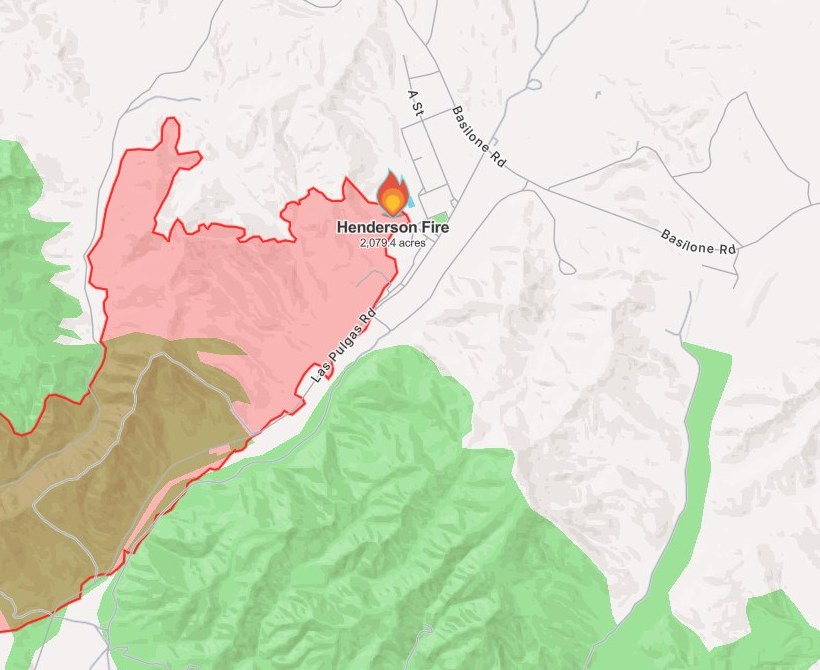
图片来源:图:Henderson Fire 态势图,Watch Duty 截图(10月16日13时50分截取,本轮重新裁切)。图中红色周界为截取时的火场范围(2,079.4英亩),西南侧橄榄色区域为疏散分区;最新官方数据以正文为准:过火面积3,160英亩(10月17日晚官方数据,本轮未调整)、控制率65%(加州消防局 CAL FIRE 官方事故页10月18日上午7时50分通报)。图片来源:Watch Duty。Situation map of the Henderson Fire, Watch Duty screenshot taken at 1:50 p.m. on Oct. 16 (re-cropped for this update). The red perimeter reflects mapping at capture time (2,079.4 acres), with the evacuation zone shaded olive at the southwest; the latest official figures are in the text: 3,160 acres (Oct. 17 evening figure, unchanged in this update) and 65% containment, per CAL FIRE's incident-page update at 7:50 a.m. on Oct. 18. Source: Watch Duty.
GSM Global · 本篇英文版 English edition of this story
- 2026-10-15 14:53San Diego County彭德尔顿营「Henderson Fire」烧至约75英亩 浓烟升腾 控制率尚未公布
- 2026-10-15 16:17跟进:彭德尔顿营「Henderson Fire」扩至约150英亩 基地外仍无疏散令
- 2026-10-15 18:51跟进:彭德尔顿营「Henderson Fire」测绘周界约1,117英亩 41区疏散令下达、I-5一度关闭后重开
- 2026-10-16 13:51跟进:彭德尔顿营「Henderson Fire」扩至2,080英亩仍零控制 I-5在Vandegrift至Basilone段双向关闭
- 2026-10-17 01:16跟进:彭德尔顿营「Henderson Fire」控制率升至20% 过火2,079英亩 I-5全线重开
- 2026-10-17 09:19跟进:彭德尔顿营「Henderson Fire」过火面积上修至3,132英亩 控制率仍为20%
- 2026-10-17 22:34跟进:彭德尔顿营「Henderson Fire」控制率升至50% 过火面积3,160英亩
- 2026-10-17 22:40综合:南加四场山火全部受控推进 Henderson控制率升至50% Norte疏散令全解
- 2026-10-18 16:24跟进:彭德尔顿营「Henderson Fire」控制率升至65% 消防员转入清场灭余火本篇
- 2026-10-19 08:11跟进:彭德尔顿营「Henderson Fire」控制率升至95% 过火面积经精确测绘修订为3,260英亩
- 2026-10-19 21:02跟进:彭德尔顿营「Henderson Fire」达到100%控制 过火面积3,260英亩