跟进:Malibu「Bryson Fire」扩至80英亩 疏散警告增至10个分区
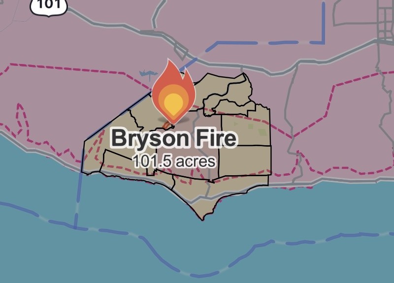
Malibu(Malibu)——洛杉矶县Malibu以北的灌木野火「Bryson Fire」10月15日傍晚继续扩大。据加州消防局(Cal Fire)当晚6时19分更新的事件页,这场火的过火面积已达80英亩,疏散警告范围扩大至10个分区,疏散令仍仅限KAN-U017一个分区。Cal Fire事件页显示,这场火的管辖机关为洛杉矶县消防局,起火原因仍在调查中,官方尚未公布控制率。Cal Fire于当晚6时06分通报面积增至80英亩,6时11分通报新增疏散警告与疏散令生效。另据火灾态势监测平台Watch Duty当晚6时44分左右的态势图(见配图),其测绘的火场范围已约101.5英亩,显示火势仍在扩大;该数字为态势平台的范围测算值,官方公布的过火面积以Cal Fire的80英亩为准。
疏散方面,目前处于疏散警告的10个分区为CRN-U019、LBO-U018、LEO-U015、MAL-C113、MAL-C114、MCR-U021-A、MLK-U020、SYC-U016、VST-U046与WLV-C201,覆盖Malibu西部大片山地与海岸一带,向西至利奥·卡里略州立公园(Leo Carrillo State Park)周边;本报首稿时,疏散警告为4个分区。居民可通过Alert LA County与Genasys Protect查询所在分区的疏散状态。
扑救方面,洛县消防局已增派地面队伍与空中力量,Ventura County消防局继续派出设备与人员增援。截至发稿,官方仍无人员伤亡报告,现场初步报告显示暂无建筑受到威胁。
前情回顾:这场火于当日下午4时30分许在恩西纳尔峡谷路(Encinal Canyon Road)400号街区一带被报告,起火点临近穆赫兰德公路(Mulholland Highway)与洛县基尔帕特里克营(Camp Kilpatrick)少年惩教设施。在Santa Ana强风助推下,火势半小时内由约半英亩扩至约20英亩,傍晚时分已逾40英亩,本报首稿报道了KAN-U017疏散令与首批疏散警告的发布。背景方面,事发时Malibu中西部正处于南加爱迪生公司(SCE)公共安全预防性断电(PSPS)之下;国家气象局对洛杉矶、Ventura等县发布的红旗警告持续至周六(10月17日)晚8时。
(资料来源:加州消防局(Cal Fire)「Bryson Fire」事件页(更新至2026年10月15日18:19);洛杉矶县消防局官员通报)
Follow-Up: Malibu Bryson Fire Grows to 80 Acres as Evacuation Warnings Expand to 10 Zones
MALIBU — The Bryson Fire, a brush fire burning in the hills north of Malibu in Los Angeles County, continued to grow on the evening of October 15. According to the California Department of Forestry and Fire Protection (Cal Fire), whose incident page was updated at 6:19 p.m., the fire has now burned 80 acres, evacuation warnings have been expanded to 10 zones, and the evacuation order remains in effect for a single zone, KAN-U017. Cal Fire lists the Los Angeles County Fire Department as the agency having jurisdiction; the cause remains under investigation, and no containment figure has been announced. Cal Fire reported the fire at 80 acres at 6:06 p.m. and noted that additional evacuation warnings and orders were in effect at 6:11 p.m. Separately, an incident map from the fire-monitoring platform Watch Duty, captured at about 6:44 p.m. (see photo), put the mapped fire perimeter at roughly 101.5 acres, indicating the fire was still growing; that figure is the platform's perimeter estimate, and Cal Fire's posted acreage of 80 acres remains the official figure.
The 10 zones now under evacuation warnings are CRN-U019, LBO-U018, LEO-U015, MAL-C113, MAL-C114, MCR-U021-A, MLK-U020, SYC-U016, VST-U046 and WLV-C201, covering a broad swath of western Malibu's mountains and coast and extending west toward Leo Carrillo State Park — up from four warning zones when GSM first reported the fire. Residents can check their zone status through Alert LA County and Genasys Protect.
The County Fire Department has dispatched additional ground crews and aircraft, and the Ventura County Fire Department continues to send equipment and personnel to assist. As of publication, there were still no reports of injuries, and initial reports from the scene indicated that no structures were threatened.
Background: the fire was reported around 4:30 p.m. in the 400 block of Encinal Canyon Road, near Mulholland Highway and the county's Camp Kilpatrick juvenile detention facility. Driven by Santa Ana winds, it grew from about half an acre to roughly 20 acres within half an hour and had passed 40 acres by early evening, when GSM's first report covered the KAN-U017 evacuation order and the first set of warnings. The fire erupted while central and western Malibu were under a Southern California Edison Public Safety Power Shutoff (PSPS); the National Weather Service Red Flag Warning for Los Angeles and Ventura counties remains in effect through 8 p.m. Saturday.
(Sources: Cal Fire Bryson Fire incident page, updated 6:19 p.m., Oct. 15, 2026; Los Angeles County Fire Department officials)
来源:GSM·美国(原文链接)
图片来源:图:Bryson Fire 态势图,Watch Duty 截图,10月15日18:44左右。图中米色分区为疏散令与疏散警告覆盖区域,态势图测绘火场范围约101.5英亩;Cal Fire公布的过火面积为80英亩。Bryson Fire incident map, Watch Duty screenshot, captured at about 6:44 p.m. on Oct. 15. The tan zones are the areas under the evacuation order and warnings; the map's perimeter estimate is about 101.5 acres, while Cal Fire's posted acreage is 80 acres.
GSM Global · 本篇英文版 English edition of this story
- 2026-10-15 18:18洛县Malibu「Bryson Fire」扩至至少40英亩 KAN-U017分区发布疏散令
- 2026-10-15 18:44跟进:Malibu「Bryson Fire」扩至80英亩 疏散警告增至10个分区本篇
- 2026-10-15 22:17跟进:Malibu「Bryson Fire」据报扩至约200英亩 红十字会在阿古拉高中开设避难所
- 2026-10-16 20:50跟进:Malibu「Bryson Fire」控制率升至39% 过火面积测绘修正为146.2英亩
- 2026-10-17 09:19跟进:Malibu「Bryson Fire」控制率升至52% 过火面积仍约147英亩
- 2026-10-17 19:21跟进:Malibu「Bryson Fire」疏散令与警告全部解除 道路重开 两处庇护点关闭
- 2026-10-17 22:40综合:南加四场山火全部受控推进 Henderson控制率升至50% Norte疏散令全解
- 2026-10-18 12:25跟进:Malibu「Bryson Fire」控制率升至68% 过火面积仍约147英亩
- 2026-10-18 22:51跟进:Malibu「Bryson Fire」控制率升至74% 过火面积仍约147英亩
- 2026-10-19 08:29跟进:Malibu「Bryson Fire」控制率升至83% 过火面积仍为147英亩
- 2026-10-20 10:23跟进:Malibu「Bryson Fire」已全面控制 过火面积约146英亩