跟进:阿祖萨「Peak Fire」测绘修正为43英亩 控制率升至41%
阿祖萨(Azusa)——10月15日下午在洛杉矶县阿祖萨市San Gabriel峡谷路(San Gabriel Canyon Road)以北山麓燃起的灌木野火「Peak Fire」,晚间经空中测绘重新核定,过火面积修正为43英亩。据统一指挥成员、美国林务局安吉利斯国家森林官员向媒体通报,截至当日下午4时45分,这场火的控制率已升至41%,火势蔓延已被遏止。需要说明的是,43英亩是空中测绘给出的更精确火场边界,属于统计口径的修正下修,并非火场在地面上缩小:本报上一篇跟进稿依据现场指挥部当时的口径,报道面积约为60英亩。41%的控制率,也是统一指挥首次公布的控制率数字,此前官方一直未公布。
疏散状态没有变化:目前已无分区处于疏散令之下,仍维持疏散警告的分区为AZU-MC01(由此前的疏散令降级)、LAC-E168-B与LAC-E170-B;AZU-ABC01、AZU-CYN01-A、AZU-NOB01、AZU-QRY01、LAC-E168-A、LAC-E170-A六个分区的警告此前已经解除。设于阿祖萨纪念公园娱乐中心(Azusa Memorial Park Recreation Center,北奥兰治大道340号,340 N Orange Ave)的疏散安置点仍在开放。加州消防局(Cal Fire)「Peak Fire」事件页截至发稿仍停留在下午2时21分的版本(记为22英亩、未列控制率、疏散栏亦未同步),本篇面积、控制率与疏散状态以安吉利斯国家森林官员的最新通报为准。
扑救方面,洛杉矶县消防局与安吉利斯国家森林继续以统一指挥作业,投水直升机从附近水库取水往返扑救,地面队伍继续为Foxtail Court与Poppyglen Court一带住宅上方的山坡做建筑防护。截至发稿,官方未发布人员伤亡或建筑损毁的报告,起火原因仍在调查中。据国家气象局,覆盖洛杉矶县大部的红旗警告持续至周六(10月17日)晚8时,区域火险仍然偏高。
前情回顾:这场火于当日下午1时许在San Gabriel峡谷路与Mirador Drive、Ranch Road一带山坡燃起,洛县消防局1时34分将其升至二级火警,Cal Fire登记的起火时间为下午1时43分。火势在数小时内迅速扩大,指挥部下午的口径一度为约50至60英亩;AZU-MC01分区一度处于疏散令之下,另有八个分区列入疏散警告,傍晚起疏散令降级、多数警告陆续解除。本报首发与首篇跟进稿记录了起火、疏散令发布与降级的经过,本篇为同一事件线的第二篇跟进。
(资料来源:安吉利斯国家森林官员通报(经MyNewsLA报道);Cal Fire「Peak Fire」事件页(更新至10月15日14:21))
Follow-Up: Azusa Peak Fire Remapped at 43 Acres as Containment Rises to 41%
AZUSA — The Peak Fire, a brush fire that broke out on the afternoon of October 15 in the foothills north of San Gabriel Canyon Road in Azusa, Los Angeles County, has been remapped by aerial survey at 43 acres. According to officials with the U.S. Forest Service's Angeles National Forest, part of the unified command, containment had risen to 41% as of 4:45 p.m., and the fire's spread has been halted. The 43-acre figure is a downward revision from more precise aerial mapping, not an actual shrinking of the fire on the ground: GSM's previous follow-up, based on incident command's figure at the time, put the size at about 60 acres. The 41% figure is also the first containment number released by unified command, which had not previously announced one.
Evacuation status is unchanged: no zone remains under an evacuation order. Zones still under an evacuation warning are AZU-MC01 (downgraded from an order), LAC-E168-B and LAC-E170-B; warnings for six other zones — AZU-ABC01, AZU-CYN01-A, AZU-NOB01, AZU-QRY01, LAC-E168-A and LAC-E170-A — were lifted earlier. The evacuation shelter at the Azusa Memorial Park Recreation Center, 340 N Orange Ave, remains open. The Cal Fire incident page for the Peak Fire still showed its 2:21 p.m. version as of publication (22 acres, no containment listed, evacuation section not yet updated), so the acreage, containment and evacuation status here follow the latest briefing from Angeles National Forest officials.
The Los Angeles County Fire Department and the Angeles National Forest continue the firefight under unified command, with water-dropping helicopters drawing from a nearby reservoir and ground crews holding structure protection on the slopes above homes near Foxtail Court and Poppyglen Court. As of publication, officials had issued no reports of injuries or structures damaged, and the cause remains under investigation. The National Weather Service Red Flag Warning covering much of Los Angeles County remains in effect through 8 p.m. Saturday, and fire danger remains elevated.
Background: the fire ignited shortly after 1 p.m. on slopes near San Gabriel Canyon Road, Mirador Drive and Ranch Road; the County Fire Department called a second alarm at 1:34 p.m., and Cal Fire lists the start time as 1:43 p.m. It grew rapidly over several hours, with incident command at one point putting it at roughly 50 to 60 acres. Zone AZU-MC01 was placed under an evacuation order and eight surrounding zones under warnings before the order was downgraded in the late afternoon and most warnings were lifted. GSM's first report and first follow-up covered the ignition, the evacuation order and its downgrade; this is the second follow-up on the same incident thread.
(Sources: Angeles National Forest officials' briefing, via MyNewsLA; Cal Fire Peak Fire incident page, updated 2:21 p.m. Oct. 15)
来源:GSM·美国(原文链接)
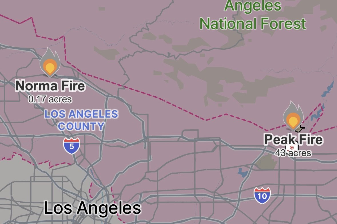
图片来源:Peak Fire 态势图,Watch Duty 截图,10 月 15 日晚:火场位于阿祖萨以北的圣盖博山麓、安吉利斯国家森林南缘、10 号公路以北,图中标注 43 英亩,与官方晚间测绘修正口径一致。图片来源:Watch Duty。 Situation map of the Peak Fire, Watch Duty screenshot, evening of Oct. 15: the fire sits in the San Gabriel foothills north of Azusa, along the southern edge of Angeles National Forest and north of Interstate 10; the 43 acres shown matches the official remapped figure. Source: Watch Duty.
GSM Global · 本篇英文版 English edition of this story
- 2026-10-15 14:45阿祖萨「Peak Fire」烧至22英亩 疏散令生效 直升机投水护房
- 2026-10-15 15:52跟进:阿祖萨「Peak Fire」扩至约60英亩 AZU-MC01疏散令降级为警告
- 2026-10-15 18:32跟进:阿祖萨「Peak Fire」测绘修正为43英亩 控制率升至41%本篇
- 2026-10-17 22:40综合:南加四场山火全部受控推进 Henderson控制率升至50% Norte疏散令全解