San Diego County彭德尔顿营「Henderson Fire」烧至约75英亩 浓烟升腾 控制率尚未公布
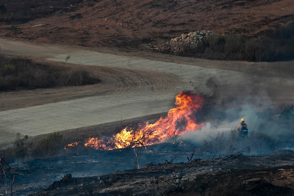
彭德尔顿营(Camp Pendleton)——10月15日下午,San Diego County海军陆战队彭德尔顿营基地内燃起灌木野火,火场代号「Henderson Fire」。据野火实时监测平台Watch Duty,该火于下午1时55分左右登记,起火点位于基地内布朗街(Brown St)与亨德森街(Henderson St)一带,彭德尔顿营消防局正在现场处置。
火势蔓延很快。据Watch Duty引述现场指挥部(Incident Command)下午2时44分的通报,过火面积已达约75英亩,蔓延速度快,火场南侧有建筑受威胁,官方尚未公布控制率;空中指挥已追加申请2架灭火飞机(air tankers)投入扑救。此前下午2时39分前后的现场估算约为10至15英亩,风速约每小时10至15英里。由加州大学San Diego分校与San Diego天然气电气公司(SDG&E)运营的ALERTCalifornia摄像头网络在下午2时04分拍到的画面显示,火场上空升起大股浓烟,山坡植被正在燃烧,画面前景可见基地建筑与道路、远景为海岸线。
疏散与影响方面,据彭德尔顿营官方消息(经Watch Duty转述),基地内基础设施受威胁,基地内已下达疏散令,基地拉斯普尔加斯(Las Pulgas,43区)一带停电,基地居民可见浓烟。需要分清的是:截至发稿,加州林业和消防局(Cal Fire)与San Diego County应急部门尚未对基地外的Oceanside(Oceanside)、福尔布鲁克(Fallbrook)、邦索尔(Bonsall)等周边社区发布疏散令或疏散警告;官方亦未报告人员伤亡或建筑损毁,未公布道路封闭信息。起火原因尚未公布。本稿将随官方数据发布持续更新。
背景方面,南加州正经历本季首场Santa Ana 风:国家气象局San Diego办公室的大风预警覆盖San Diego County内陆、山区与山麓地带,山区阵风可达每小时65英里,海岸地区高温预警生效至周六;洛杉矶、Ventura两县的红旗警告持续至周六(10月17日)晚8时。同日下午,洛杉矶县阿祖萨(Azusa)的「Peak Fire」烧至22英亩并触发疏散令,本站已另行报道。需说明的是,本场火与2025年5月San Diego County帕拉(Pala)一带同名的「Henderson Fire」是两起不同事件。
(资料来源:Watch Duty事件页及其实时运营通报(10月15日14:44,引述现场指挥部与彭德尔顿营官方)、ALERTCalifornia摄像头画面(10月15日14:04)、国家气象局San Diego办公室预警)
Henderson Fire Burns About 75 Acres on Camp Pendleton in San Diego County; Containment Not Yet Announced
CAMP PENDLETON — A brush fire broke out on the afternoon of October 15 inside Marine Corps Base Camp Pendleton in San Diego County and was named the Henderson Fire. According to the wildfire monitoring platform Watch Duty, the incident was logged at about 1:55 p.m., with the fire burning in the area of Brown Street and Henderson Street on the base. The Camp Pendleton Fire Department is responding.
The fire is spreading fast. In a 2:44 p.m. update relaying Incident Command, Watch Duty reported the fire at about 75 acres with a fast rate of spread and a structure threat on its south side; no containment figure has been announced. Air Attack has requested two additional air tankers. An earlier estimate at about 2:39 p.m. had put the fire at roughly 10 to 15 acres in winds of 10 to 15 mph. Images captured at 2:04 p.m. by the ALERTCalifornia camera network, operated by UC San Diego and San Diego Gas & Electric, showed a large column of smoke rising over the fire, with brush burning on a hillside, base buildings and roads in the foreground and the coastline in the distance.
On evacuations and impacts, base officials said — as relayed by Watch Duty — that infrastructure on the base is threatened and evacuations have been ordered on base; there is a power outage in the Las Pulgas (43 Area) part of the base, and smoke may be visible to base residents. To be clear, as of publication neither Cal Fire nor San Diego County emergency officials had issued an evacuation order or evacuation warning for the off-base communities of Oceanside, Fallbrook or Bonsall. Officials had also reported no injuries or structure damage and announced no road closures. The cause has not been announced. This story will be updated as official figures are released.
The fire comes as Southern California experiences its first Santa Ana wind event of the season. A National Weather Service high wind warning covers San Diego County's inland, mountain and foothill areas, with mountain gusts up to 65 mph, and a heat advisory is in effect for coastal areas through Saturday; a Red Flag Warning for Los Angeles and Ventura counties runs through 8 p.m. Saturday. Earlier Thursday, the Peak Fire in Azusa, Los Angeles County, grew to 22 acres and triggered an evacuation order, as reported separately by GSM. Note that this incident is separate from the May 2025 wildfire of the same name that burned near Pala in San Diego County.
(Sources: Watch Duty incident page and real-time operations report, 2:44 p.m. Oct. 15, relaying Incident Command and Camp Pendleton officials; ALERTCalifornia camera images, 2:04 p.m. Oct. 15; National Weather Service San Diego warnings.)
来源:GSM·美国(原文链接)
图片来源:图:彭德尔顿营消防员在基地内灌木火现场扑灭一处火点(资料照片)。美国海军陆战队Cpl. Brian Bekkala摄,公共领域,经DVIDS发布。File photo: a Camp Pendleton firefighter sprays water on a spot fire during a brush fire on base. U.S. Marine Corps photo by Cpl. Brian Bekkala, public domain, via DVIDS.
GSM Global · 本篇英文版 English edition of this story
- 2026-10-15 14:53San Diego County彭德尔顿营「Henderson Fire」烧至约75英亩 浓烟升腾 控制率尚未公布本篇
- 2026-10-15 16:17跟进:彭德尔顿营「Henderson Fire」扩至约150英亩 基地外仍无疏散令
- 2026-10-15 18:51跟进:彭德尔顿营「Henderson Fire」测绘周界约1,117英亩 41区疏散令下达、I-5一度关闭后重开
- 2026-10-16 13:51跟进:彭德尔顿营「Henderson Fire」扩至2,080英亩仍零控制 I-5在Vandegrift至Basilone段双向关闭
- 2026-10-17 01:16跟进:彭德尔顿营「Henderson Fire」控制率升至20% 过火2,079英亩 I-5全线重开
- 2026-10-17 09:19跟进:彭德尔顿营「Henderson Fire」过火面积上修至3,132英亩 控制率仍为20%
- 2026-10-17 22:34跟进:彭德尔顿营「Henderson Fire」控制率升至50% 过火面积3,160英亩
- 2026-10-17 22:40综合:南加四场山火全部受控推进 Henderson控制率升至50% Norte疏散令全解
- 2026-10-18 16:24跟进:彭德尔顿营「Henderson Fire」控制率升至65% 消防员转入清场灭余火
- 2026-10-19 08:11跟进:彭德尔顿营「Henderson Fire」控制率升至95% 过火面积经精确测绘修订为3,260英亩
- 2026-10-19 21:02跟进:彭德尔顿营「Henderson Fire」达到100%控制 过火面积3,260英亩