跟进:Malibu「Bryson Fire」控制率升至68% 过火面积仍约147英亩
洛杉矶县——加州消防局(CAL FIRE)10月18日清晨6时58分在官方事故页更新:Malibu 以北的灌木野火「Bryson Fire」控制率升至68%,过火面积不变。当天上午10时21分,事故页再次更新,确认过火面积与控制率均无变化,这场火的过火面积仍为约147英亩(此前测绘146.2英亩)。
控制率进程逐项回看:这场火10月17日清晨通报为52%,当天下午5时09分升至61%,10月18日清晨进一步升至68%。疏散方面,全部疏散令与疏散警告已于10月17日晚6时20分解除,KAN-017与SYC-016-A两个分区仍保留疏散提示,居民应保持警觉、做好在情况变化时随时撤离的准备;因火封闭的道路此前已全部重开,设在 Agoura High School 的居民庇护点与 Pierce College 的大型动物庇护点已经关闭。
损毁与伤亡方面,据洛杉矶县警长局(LASD)此前通报,这场山火没有造成建筑损毁或损坏,消防人员仅受轻伤。起火原因仍在调查中。
这场火于10月15日下午约4时41分起于 Encinal Canyon Road 附近的 Encinal Canyon 一带,当晚一度据报约200英亩并引发多区疏散令与警告;10月16日测绘修正为146.2英亩,控制率经5%、17%、39%逐步上升,10月17日升至52%并于当晚解除全部疏散令与警告,10月18日清晨控制率升至68%。
Update: Bryson Fire Near Malibu Reaches 68% Containment; Size Holds at About 147 Acres
LOS ANGELES COUNTY — CAL FIRE updated its official incident page at 6:58 a.m. on Sunday, October 18: containment of the Bryson Fire, the brush fire burning north of Malibu, has risen to 68%, with no change in size. In a further update at 10:21 a.m., the incident page confirmed no change to acreage or containment; the fire remains at about 147 acres (previously mapped at 146.2 acres).
The containment sequence, step by step: the fire stood at 52% on the morning of October 17, rose to 61% at 5:09 p.m. that day, and reached 68% on the morning of October 18. On evacuations, all evacuation orders and warnings were lifted at 6:20 p.m. on October 17; evacuation advisories remain in effect for Zones KAN-017 and SYC-016-A, where residents should stay alert and be ready to leave if conditions change. Roads closed by the fire had already reopened, and the resident shelter at Agoura High School and the large-animal shelter at Pierce College have closed.
On damage and injuries, the Los Angeles County Sheriff's Department (LASD) previously reported no structures damaged or destroyed and only minor injuries to fire personnel. The cause remains under investigation.
The fire began at about 4:41 p.m. on October 15 near Encinal Canyon Road in the Encinal Canyon area. It was reported at about 200 acres that evening as evacuation orders and warnings spread across multiple zones; mapping on October 16 revised the size to 146.2 acres, and containment climbed through 5%, 17% and 39% before reaching 52% on October 17, when all evacuation orders and warnings were lifted that evening. Containment rose to 68% on the morning of October 18.
来源:GSM·美国(原文链接)
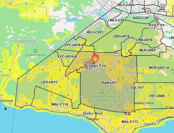
图片来源:图:Bryson Fire 态势图,Watch Duty 截图(10月16日20时45分截取,本轮重新裁切)。图中火场位于 Malibu 以北 Encinal Canyon 一带,KAN-U017 与 SYC-016-A 两区当时为疏散令分区——该批疏散令与警告已于10月17日晚全部解除,两区现为疏散提示;火场面积自截取时起无变化。最新官方数据以正文为准:过火面积约147英亩、控制率68%(加州消防局 CAL FIRE 10月18日通报)。图片来源:Watch Duty。Situation map of the Bryson Fire, Watch Duty screenshot taken at 8:45 p.m. on Oct. 16 (re-cropped for this update). The fire sits in the Encinal Canyon area north of Malibu; zones KAN-017 and SYC-016-A, shown under evacuation orders at capture time, had all orders and warnings lifted on the evening of Oct. 17 and are now under advisories, and the fire's size has not changed since capture. The latest official figures are in the text: about 147 acres and 68% containment, per CAL FIRE on October 18. Source: Watch Duty.
GSM Global · 本篇英文版 English edition of this story
- 2026-10-15 18:18洛县Malibu「Bryson Fire」扩至至少40英亩 KAN-U017分区发布疏散令
- 2026-10-15 18:44跟进:Malibu「Bryson Fire」扩至80英亩 疏散警告增至10个分区
- 2026-10-15 22:17跟进:Malibu「Bryson Fire」据报扩至约200英亩 红十字会在阿古拉高中开设避难所
- 2026-10-16 20:50跟进:Malibu「Bryson Fire」控制率升至39% 过火面积测绘修正为146.2英亩
- 2026-10-17 09:19跟进:Malibu「Bryson Fire」控制率升至52% 过火面积仍约147英亩
- 2026-10-17 19:21跟进:Malibu「Bryson Fire」疏散令与警告全部解除 道路重开 两处庇护点关闭
- 2026-10-17 22:40综合:南加四场山火全部受控推进 Henderson控制率升至50% Norte疏散令全解
- 2026-10-18 12:25跟进:Malibu「Bryson Fire」控制率升至68% 过火面积仍约147英亩本篇
- 2026-10-18 22:51跟进:Malibu「Bryson Fire」控制率升至74% 过火面积仍约147英亩
- 2026-10-19 08:29跟进:Malibu「Bryson Fire」控制率升至83% 过火面积仍为147英亩
- 2026-10-20 10:23跟进:Malibu「Bryson Fire」已全面控制 过火面积约146英亩