国家气象局对加州中央海岸发布巨浪预警,碎浪可达25英尺,南加多县高浪提示持续至11月17日
美国国家气象局洛杉矶/Oxnard 办公室 11 月 12 日发布巨浪预警(High Surf Warning):加利福尼亚州圣巴巴拉县中央海岸与圣路易斯奥比斯波县的海滩,11 月 13 日(周五)晚 9 时至 11 月 15 日(周日)凌晨 3 时将出现 18 至 25 英尺的碎浪和危险离岸流。文图拉县、洛杉矶县、橙县与圣迭戈县海岸同期发布高浪提示,一系列西北向长周期涌浪将使南加海岸的大浪天气至少持续到 11 月 17 日(周二)。
预警生效前,上述中央海岸海滩先处于高浪提示之下,碎浪 10 至 15 英尺,持续至周五晚 9 时。气象局同时对同一带发布海岸洪水预警:周六(14 日)凌晨 3 时至下午 6 时,涨潮时段海水可能漫过低洼海岸,淹没海滩、步道和道路,并可能损坏建筑物;Oceano Dunes 一带预计出现大面积淹水,碎浪还可能冲击 Cayucos 和 Pismo Beach 的栈桥以及 Morro Bay 的港口入口。气象局表示,强浪与离岸流造成的溺水风险极高,大浪能把人卷下海滩和礁石、掀翻近岸小船,民众应远离水边,不要登上栈桥和防波堤,也不要驾车穿过积水路段。
文图拉县海滩的高浪提示已于 12 日下午生效,持续至 17 日下午 3 时:碎浪先为 4 至 7 英尺,周五至周二增至 8 至 14 英尺,周六达到峰值,周一可能再度增强,周六还有低概率升至预警级别,Ventura 港入口可能出现碎浪。Malibu 海岸与洛杉矶县海滩的高浪提示自周五下午 2 时起生效,同样持续至 17 日下午 3 时,碎浪周五 4 至 7 英尺、周六增至 7 至 12 英尺、周日至周二回落到 6 至 9 英尺,周六还可能出现中度海岸洪水和海滩侵蚀。
气象局圣迭戈办公室对橙县海岸和圣迭戈县海岸发布高浪提示,周五下午 4 时至周日上午 10 时生效:朝向西北的海滩碎浪 5 至 7 英尺,阵浪可达 8 至 9 英尺,离岸流风险高。经调整的涨潮水位可达约 7 英尺,与高浪叠加后,海水可能漫入停车场和木板步道,并造成局部海滩侵蚀。浪势周日午后减弱,但朝西海滩的大浪可能持续到周一上午。气象局提醒,游泳和冲浪条件危险,经验不足的游泳者不要下水。
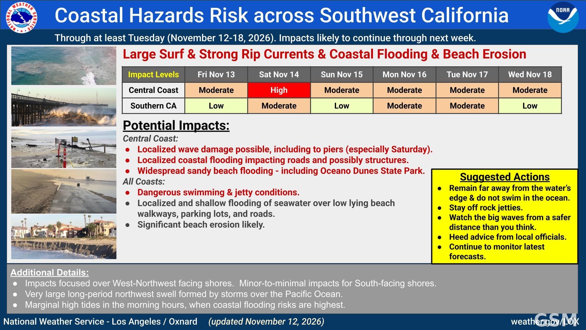
气象局说,这轮大浪由太平洋上的风暴系统生成,一系列西北向长周期涌浪接连抵达,影响至少持续到下周;周日晚间至周一,中央海岸的浪高可能再度达到预警级别。沿海影响以朝向西北的海滩最严重,朝南海滩影响较小,清晨涨潮时段是海岸洪水风险最高的时段。
(来源:国家气象局)
High Surf Warning Issued for California's Central Coast With Waves to 25 Feet; Advisories Across Southern California Through Nov. 17
The National Weather Service office in Los Angeles/Oxnard issued a High Surf Warning on November 12 for the Central Coast beaches of Santa Barbara County and the beaches of San Luis Obispo County, California: from 9 p.m. Friday, November 13, to 3 a.m. Sunday, November 15, breaking waves of 18 to 25 feet are expected, along with dangerous rip currents. High Surf Advisories are in effect at the same time for the coasts of Ventura, Los Angeles, Orange and San Diego counties, and a series of long-period west-northwest swells will keep large surf along the Southern California coast through at least Tuesday, November 17.
Before the warning takes effect, the Central Coast beaches are under a High Surf Advisory with breaking waves of 10 to 15 feet through 9 p.m. Friday. The Weather Service has also issued a Coastal Flood Warning for the same stretch of coast: from 3 a.m. to 6 p.m. Saturday, November 14, seawater may flood low-lying coastal areas around high tide, inundating beaches, walkways and roads and potentially damaging some structures. Widespread flooding is likely at Oceano Dunes, and breaking waves may impact the Cayucos and Pismo Beach piers as well as the Morro Bay Harbor entrance. The agency says powerful waves and strong rip currents pose an exceptional risk of ocean drowning; large waves can wash people off beaches and rocks and capsize small boats near shore. Everyone should remain out of the water and stay off beaches, jetties and piers, and drivers should not go through water of unknown depth.
In Ventura County, a High Surf Advisory took effect Thursday afternoon and runs through 3 p.m. Tuesday: breaking waves of 4 to 7 feet at first, increasing to 8 to 14 feet Friday through Tuesday, peaking Saturday and possibly again Monday. There is a low chance of warning-level surf on Saturday, and breaking waves are possible at the Ventura Harbor entrance. For the Malibu Coast and Los Angeles County Beaches, a High Surf Advisory runs from 2 p.m. Friday through 3 p.m. Tuesday, with surf of 4 to 7 feet Friday, 7 to 12 feet Saturday, and 6 to 9 feet Sunday through Tuesday; moderate coastal flooding and beach erosion are possible on Saturday.
The Weather Service office in San Diego has a High Surf Advisory in effect for the Orange County coast and the San Diego County coast from 4 p.m. Friday to 10 a.m. Sunday: breaking waves of 5 to 7 feet with sets to 8 to 9 feet at northwest-facing beaches, and a high rip current risk. Adjusted high tides near 7 feet could combine with the surf to push water into parking lots and boardwalks and cause localized beach erosion. The surf wanes Sunday afternoon but may remain elevated for west-facing beaches into Monday morning. Inexperienced swimmers should stay out of the water.
The Weather Service says the episode is driven by a series of west-northwesterly swells generated by storms over the Pacific Ocean, producing an extended period of large surf into next week; warning-level surf is possible again on the Central Coast late Sunday night through Monday. Impacts will be greatest on west-northwest-facing beaches and minor for south-facing shores, and morning high tides are when the coastal flooding risk is highest.
(Source: National Weather Service)
来源:国家气象局
发布:GSM·美国(发布链接)
图片来源:图:国家气象局洛杉矶/Oxnard 办公室 11 月 12 日发布的西南加州海岸风险图,中央海岸周六的影响等级为「高」。 / Image: Coastal hazards risk graphic for Southwest California issued by the National Weather Service Los Angeles/Oxnard office on November 12; impact level for the Central Coast is High on Saturday.
GSM Global · 本篇英文版 English edition of this story