厄尔尼诺继续增强:气候预测中心估「超级厄尔尼诺」概率约六成,加州今冬偏湿风险上升
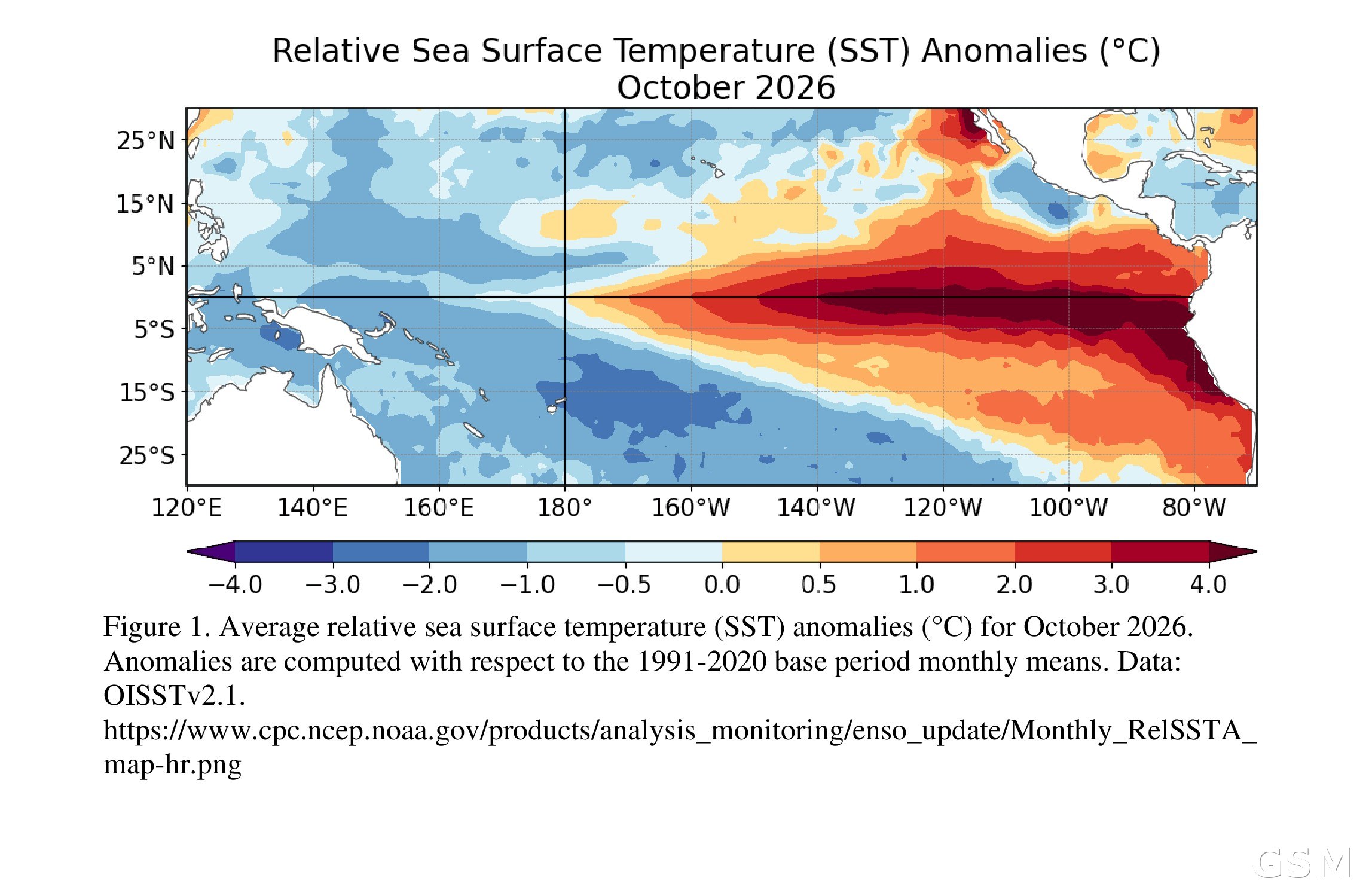
美国国家海洋和大气管理局(NOAA)气候预测中心(CPC)11月12日发布最新一期ENSO诊断讨论:厄尔尼诺过去一个月继续增强,赤道东太平洋海表温度偏高幅度超过4.0°C,异常暖水带进一步向西扩展。气候预测中心预计,强至非常强的厄尔尼诺将持续到2027年1月至3月,概率超过79%;本轮事件发展成历史级强事件、即所谓「超级厄尔尼诺」的概率约为六成。对加州来说,这意味着今冬降水偏多、风暴更频繁的风险上升,但气候预测中心强调,这类影响只是可能性更高,并不保证一定发生。
最新观测读数显示,衡量厄尔尼诺强弱的几个关键海温指数全线走高:Niño-3.4区指数达到+2.5°C,Niño-3区为+3.6°C,最东端的Niño-1+2区高达+4.4°C。赤道太平洋次表层(西经180度至100度平均)的温度同样显著偏高,温跃层比常年更深,东太平洋深层海水温度偏高幅度超过+10.0°C,为表层暖水提供持续补充。大气一侧,赤道太平洋低层西风异常与高层东风异常并存,中东部对流和降雨增强,印度尼西亚上空则受到抑制,南方涛动指数持续为负。气候预测中心表示,海洋与大气系统整体反映的正是厄尔尼诺的持续演进,ENSO警报状态维持「厄尔尼诺公告」。
所谓「超级厄尔尼诺」,指的是强度冲到历史最前列的厄尔尼诺事件。气候预测中心现行以相对海洋尼诺指数(RONI)衡量强度:如果三个月平均的RONI值达到+2.5°C或更高,本轮事件将超过1950年有记录以来所有的厄尔尼诺。综合北美与海外多个模式的官方展望显示,厄尔尼诺会先继续增强,到2027年初才开始减弱,峰值落在今冬;今年10月至12月与11月至1月两个滑动季度达到上述历史级门槛的概率,目前都估在约60%,仍高于五成。值得注意的是,事件本身在增强,但「破纪录」的概率较上月讨论时给出的83%有所回落,气候预测中心对影响的表述也保持克制:即便出现非常强的厄尔尼诺,经历与之相符的天气影响的可能性只是更高,并非必然。
对加州今冬的含义,主要在降水一侧。按美国国家海洋和大气管理局冬季展望的口径,强厄尔尼诺主导的冬季里,美国北部通常偏暖,南部一带降水偏多,加州特别是南加州处于降水偏多倾向的覆盖范围之内,副热带急流带来的风暴与大气河流也可能更活跃。加州从州府到各县市已提前数月备防,囤积沙袋、清理排水系统、多地宣布本地紧急状态。不过气候预测中心提醒,厄尔尼诺给出的只是季节尺度上的概率倾向,具体每一场风暴的路径与雨量仍取决于当时的天气形势,不能据此断定今冬一定多雨。
气候预测中心下一期ENSO诊断讨论定于12月10日发布,届时将更新本轮事件的强度评估与概率判断。
关联:NOAA发布冬季展望:强厄尔尼诺主导今冬 美国北部偏暖、南部多雨雪
关联:迎战今冬厄尔尼诺 加州提前布防:沙袋、水泵与堤防巡查全面铺开
El Niño Keeps Strengthening: CPC Puts Odds of a 'Super El Niño' Near 60%, Raising California's Wet-Winter Risk
El Niño strengthened further over the past month and now has about a 60% chance of becoming a historic "Super El Niño," the Climate Prediction Center (CPC) of the National Oceanic and Atmospheric Administration (NOAA) said in its latest ENSO Diagnostic Discussion, issued on November 12. Sea surface temperature anomalies exceeded 4.0°C across the eastern equatorial Pacific and the band of anomalous warmth extended farther west. The CPC expects a strong-to-very strong El Niño to persist through January-March 2027, with a probability of more than 79%. For California, the outlook raises the risk of a wetter, stormier winter, though the CPC stressed that such impacts are more likely, not guaranteed.
The latest observations show all of the key sea surface temperature indices climbing: the Niño-3.4 index reached +2.5°C, Niño-3 reached +3.6°C, and Niño-1+2, at the far eastern end, reached +4.4°C. Below the surface, equatorial subsurface temperatures (averaged from 180° to 100°W) remained significantly above average, with a deeper-than-average thermocline and anomalies exceeding +10.0°C at depth in the eastern Pacific, continually feeding the warm surface waters. In the atmosphere, low-level westerly and upper-level easterly wind anomalies extended across the equatorial Pacific, convection and rainfall stayed enhanced from the central to the eastern Pacific while conditions remained suppressed over Indonesia, and the Southern Oscillation indices were consistently negative. The CPC said the coupled ocean-atmosphere system reflects the ongoing evolution of El Niño, and the ENSO alert status remains an El Niño Advisory.
A "Super El Niño" refers to an event whose strength ranks at the very top of the historical record. The CPC now measures intensity with the Relative Oceanic Niño Index (RONI): if the three-month RONI value reaches +2.5°C or more, this event would exceed every El Niño dating back to 1950. The CPC's official outlook, which synthesizes models from North America and abroad, indicates El Niño will keep strengthening before beginning to weaken in early 2027, peaking this winter. The chances of reaching that historic threshold are now estimated at about 60% for both the October-December and November-January periods, still better than even odds. Notably, while the event itself is strengthening, the odds of a record-breaking outcome have eased from the 83% given for October-December in last month's discussion, and the CPC kept its language on impacts cautious: even with a very strong El Niño, the chances of experiencing impacts consistent with El Niño are higher, though not guaranteed.
For California, the main implication is on the precipitation side. Under NOAA's winter outlook, winters dominated by a strong El Niño typically run warmer across the northern United States and wetter across the southern tier, and California, especially Southern California, falls within the area tilted toward above-average precipitation, with a potentially more active subtropical jet stream bringing storms and atmospheric rivers. State, county and city agencies across California have spent months preparing, stockpiling sandbags, clearing drainage systems and declaring local emergencies in a number of jurisdictions. The CPC cautioned, however, that El Niño provides only a seasonal-scale shift in probabilities: the track and rainfall of any individual storm still depend on the weather pattern at the time, and a wet winter cannot be assumed.
The next ENSO Diagnostic Discussion is scheduled for December 10, when the CPC will update its assessment of the event's strength and probabilities.
Related: NOAA Winter Outlook: Strong El Niño to Dominate This Winter, Warmer North and Wetter South
来源:美国国家海洋和大气管理局气候预测中心
发布:GSM·美国(发布链接)
图片来源:赤道太平洋2026年10月相对海表温度距平图:东太平洋大片海域海温偏高超过4.0°C。图:美国国家海洋和大气管理局气候预测中心(NOAA Climate Prediction Center),公共领域。Photo: Relative sea surface temperature anomalies in the equatorial Pacific for October 2026, with anomalies exceeding +4.0°C across the eastern Pacific. (NOAA Climate Prediction Center, public domain)
GSM Global · 本篇英文版 English edition of this story