跟进:圣胡安河今晚洪峰预报22英尺或破1911年纪录:Pagosa Springs低洼区强制疏散
美国国家气象局(National Weather Service,NWS)Grand Junction 办公室 11 月 1 日上午 9 时 30 分(山地时间)发布的河流洪水警告称,科罗拉多州西南部 Archuleta 县境内、流经 Pagosa Springs 的圣胡安河将出现重大洪水,情况被定为「特别危险情形」(Particularly Dangerous Situation),警告有效期至周一(11 月 2 日)晚间。
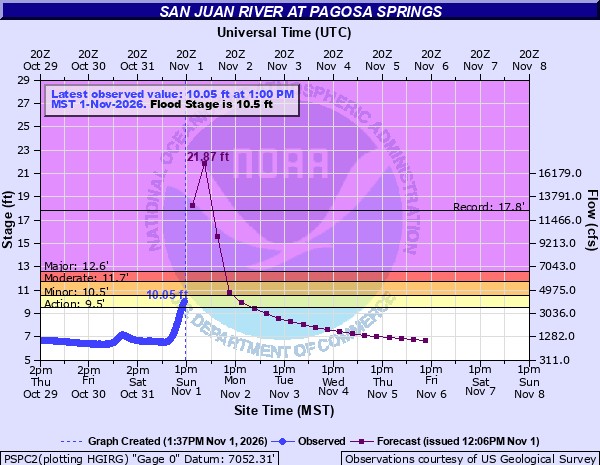
据该警告,周日上午 9 时圣胡安河水位为 7.8 英尺,洪水位为 10.5 英尺;预计河流周日下午涨过洪水位,今晚达到洪峰 22.0 英尺,周一下午回落至洪水位以下。气象局在警告中给出的历史对照是 1911 年 10 月 5 日的 17.8 英尺——那是这条河有记录以来的最高洪峰,当年的大洪水冲毁了 Pagosa 镇的大部分地区。美国国家海洋和大气管理局(NOAA)的河流预报模型给出的洪峰约为 19.7 英尺,同样高于 1911 年纪录。气象局还指出,水位达到 20 英尺时,San Juan River Ranch 的进出道路将被淹没,部分住宅无法进出。
疏散方面,Archuleta 县发布的官方更新显示,圣胡安河、Rio Blanco 河、Navajo 河与 Piedra 河沿岸全部低洼地区的强制疏散令仍在执行;Pagosa Springs 镇已对受洪水威胁区域的居民、商户与访客下达强制疏散令,重点是圣胡安河沿岸走廊与低洼地区。县府周日上午再发疏散更新,原文称:「如果你身在疏散区,就必须立即离开。这包括圣胡安河、Rio Blanco 河、Navajo 河与 Piedra 河沿岸的全部低洼地区。不要等水涨起来,不要再等另一道警告,现在就走。」县府同时正调集增援搜救力量,包括地面与空中支援以及科罗拉多州国民警卫队。县警长办公室的 Vicki Shaffer 表示,周日晚间至周一上午,救援人员可能无法及时赶到受困者身边。
交通与市政方面,镇内的 San Juan Street 与 Hermosa Street 自 11 月 1 日上午 6 时起禁止车辆通行,镇中心沿河一带商户自周日上午 6 时起停业,直至另行通知。气象局同日还对 Archuleta 县中南部发布了多道洪水警告,涉及 Navajo 河、Little Navajo 河与 Stove Creek 等支流,有效期至周一晚间;圣胡安山区另有冬季风暴警告,高海拔地区可降雪。
这已是该地区不到两周内遭遇的第二轮严重洪水。10 月下旬的上一轮洪灾中,Pagosa Springs 一带河水泛滥、破坏规模空前,全州西南部公路毁损估算达 6,500 万美元,科罗拉多州交通厅已申请联邦紧急救济资金修复公路网(见关联)。县府预计,本周日至周一上午当地降雨量接近 3 英寸,灾情可能超过上一轮。洪峰过后,本站将继续跟进水位与灾情。
关联:6500万美元公路毁损:科罗拉多州西南部洪灾第8天,州应急中心10月30日维持一级响应、国民警卫队已救出50人
Follow-Up: San Juan River Forecast to Crest at 22 Feet Tonight, Topping the 1911 Record: Mandatory Evacuations in Pagosa Springs
A river flood warning issued at 9:30 a.m. MST on Sunday, November 1, by the National Weather Service office in Grand Junction says major flooding is forecast on the San Juan River at Pagosa Springs in Archuleta County, southwestern Colorado, in what the service calls a Particularly Dangerous Situation. The warning runs until Monday evening, November 2.
At 9:00 a.m. Sunday the river stood at 7.8 feet, against a flood stage of 10.5 feet. The river is expected to rise above flood stage Sunday afternoon and crest at 22.0 feet Sunday night, then fall below flood stage early Monday afternoon. The warning's flood-history comparison is the 17.8-foot crest of October 5, 1911, the highest on record, when flooding destroyed much of the town of Pagosa. NOAA's river forecast model puts the crest near 19.7 feet, also above the 1911 record. At 20.0 feet, the Weather Service notes, access roads to the San Juan River Ranch are flooded and some homes become inaccessible.
Mandatory evacuation orders remain in effect for all low-lying areas along the San Juan, Rio Blanco, Navajo and Piedra rivers, according to Archuleta County's published update, and the Town of Pagosa Springs has issued a mandatory evacuation order for residents, businesses and visitors in flood-threatened areas, particularly along the San Juan River corridor and in low-lying areas. In a further update on Sunday morning, the county said: "If you are in an evacuation zone, you must leave now. This includes all low-lying areas along the San Juan, Rio Blanco, Navajo, and Piedra Rivers. Do not wait for the water to rise. Do not wait for another warning. Leave now." The county is bringing in additional search-and-rescue resources, including ground and air support and the Colorado National Guard. Vicki Shaffer of the Archuleta County Sheriff's Office said help may not be able to reach people in time on Sunday evening and Monday morning.
In town, San Juan Street and Hermosa Street closed to through traffic at 6:00 a.m. on November 1, and businesses along the river in downtown Pagosa Springs closed from 6:00 a.m. Sunday until further notice. The Weather Service also has flood warnings in effect for south central Archuleta County, covering the Navajo River, the Little Navajo River and Stove Creek, until Monday evening, and a winter storm warning is in effect for the San Juan Mountains, where high elevations may see snow.
This is the second severe flood to hit the area in under two weeks. In late October, flooding around Pagosa Springs caused damage the sheriff described as unprecedented, road damage across southwestern Colorado was estimated at $65 million, and the Colorado Department of Transportation applied for federal emergency relief funds to repair the road network. The county expects nearly three inches of rain from Sunday into Monday morning and says this event may exceed the last one. GSM will follow the crest and its aftermath.
来源:GSM·美国(原文链接)
图片来源:图:美国国家气象局(NOAA)圣胡安河 Pagosa Springs 水文站(PSPC2)11月1日发布的水位预报图:预报今晚洪峰约21.9英尺(紫色预报线),将超过1911年17.8英尺的历史纪录线;该河段洪水位为10.5英尺。观测数据由美国地质调查局(USGS)提供。美国联邦政府作品,公共领域。 / NWS (NOAA) forecast hydrograph for the San Juan River at Pagosa Springs (gauge PSPC2), issued Nov 1: the river is forecast to crest at about 21.9 ft tonight (purple forecast line), above the 1911 record of 17.8 ft; flood stage is 10.5 ft. Observations courtesy of the US Geological Survey. US federal government work, public domain.
GSM Global · 本篇英文版 English edition of this story
- 2026-10-23 16:58科罗拉多州洪灾持续:州长口头宣布灾害紧急状态 州应急中心一级响应
- 2026-10-23 18:18美国红十字会响应科罗拉多州洪灾:在 Archuleta 县设疏散中心并开放避难所
- 2026-10-29 01:58跟进:科罗拉多州交通厅申请6500万美元联邦紧急救济,修复西南部洪灾受损公路网
- 2026-10-30 12:386500万美元公路毁损:科罗拉多州西南部洪灾第8天,州应急中心10月30日维持一级响应、国民警卫队已救出50人
- 2026-11-01 12:39跟进:圣胡安河今晚洪峰预报22英尺或破1911年纪录:Pagosa Springs低洼区强制疏散本篇