墨西哥恰帕斯近海发生7.3级地震,海啸威胁数小时后解除
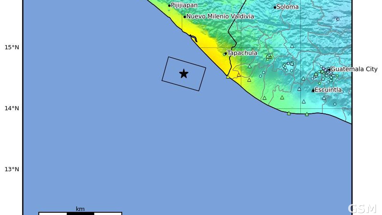
美国地质调查局(USGS)测定,2026年7月17日14时48分(UTC),墨西哥恰帕斯州 Puerto Madero 以西偏南约60公里的近海发生7.3级地震(Mww),震源深度22公里,震中位于北纬14.571度、西经92.962度。这是墨西哥2026年最强的地震之一,USGS 的 PAGER 系统给出黄色警报,全网收到288份有感报告,最大修正麦卡利烈度为VI级以上。
地震发生后,太平洋海啸预警中心对墨西哥与危地马拉太平洋沿岸发出海啸威胁信息。Puerto Madero 测得约0.3米的海啸波高;到当日17时(UTC),预警中心确认海啸威胁大体已经过去。
墨西哥总统辛鲍姆在与恰帕斯州和塔巴斯科州州长通话后表示,两州均未报告重大损失或伤亡;危地马拉总统 Bernardo Arévalo 确认危地马拉无人死亡。据美联社报道,墨西哥南部至少2人受伤,民防部门的数字最高为4人,恰帕斯沿海地区报告有墙体与屋顶局部坍塌、燃气泄漏与建筑裂缝。
主震之后余震不断,7月19日同一海域再发生5.5级余震。墨西哥国家地震局(SSN)对主震的测定为7.4级,与 USGS 的7.3级略有差别。
Magnitude 7.3 Earthquake Strikes Off Chiapas, Mexico; Tsunami Threat Passes Within Hours
A magnitude 7.3 (Mww) earthquake struck off the coast of Chiapas, Mexico, at 14:48 UTC on July 17, 2026, about 60 kilometers west-southwest of Puerto Madero, at a depth of 22 kilometers, according to the U.S. Geological Survey (event us7000t1bu, centered at 14.571°N, 92.962°W). It was among the strongest earthquakes to hit Mexico in 2026. The USGS PAGER system issued a yellow alert; the event drew 288 felt reports.
After the quake, the Pacific Tsunami Warning Center issued a tsunami threat message for the Pacific coasts of Mexico and Guatemala. A tsunami of about 0.3 meters was measured at Puerto Madero, and by 17:00 UTC the center determined that the threat had largely passed.
Mexican President Claudia Sheinbaum said, after speaking with the governors of Chiapas and Tabasco, that neither state reported major damage or casualties, and Guatemalan President Bernardo Arévalo confirmed there were no deaths in Guatemala. The Associated Press reported at least two people injured in southern Mexico, with civil protection figures running as high as four, along with partial wall and roof collapses, gas leaks, and structural cracks along the Chiapas coast.
Aftershocks continued, including a magnitude 5.5 aftershock in the same offshore area on July 19. Mexico's National Seismological Service (SSN) measured the mainshock at magnitude 7.4, slightly above the USGS figure of 7.3.
来源:美国地质调查局
发布:GSM·美国(发布链接)
图片来源:图:美国地质调查局发布的本次地震 ShakeMap 烈度图,星标为震中,位于墨西哥恰帕斯州塔帕丘拉以西近海。美国地质调查局,公共领域。 / Photo: USGS ShakeMap intensity map for this earthquake; the star marks the epicenter off the coast near Tapachula, Chiapas, Mexico. U.S. Geological Survey, public domain.
GSM Global · 本篇英文版 English edition of this story