跟进:国家公园管理局启动 Annenberg 野生动物通道科学监测 远程相机记录动物使用 12月2日正式开放
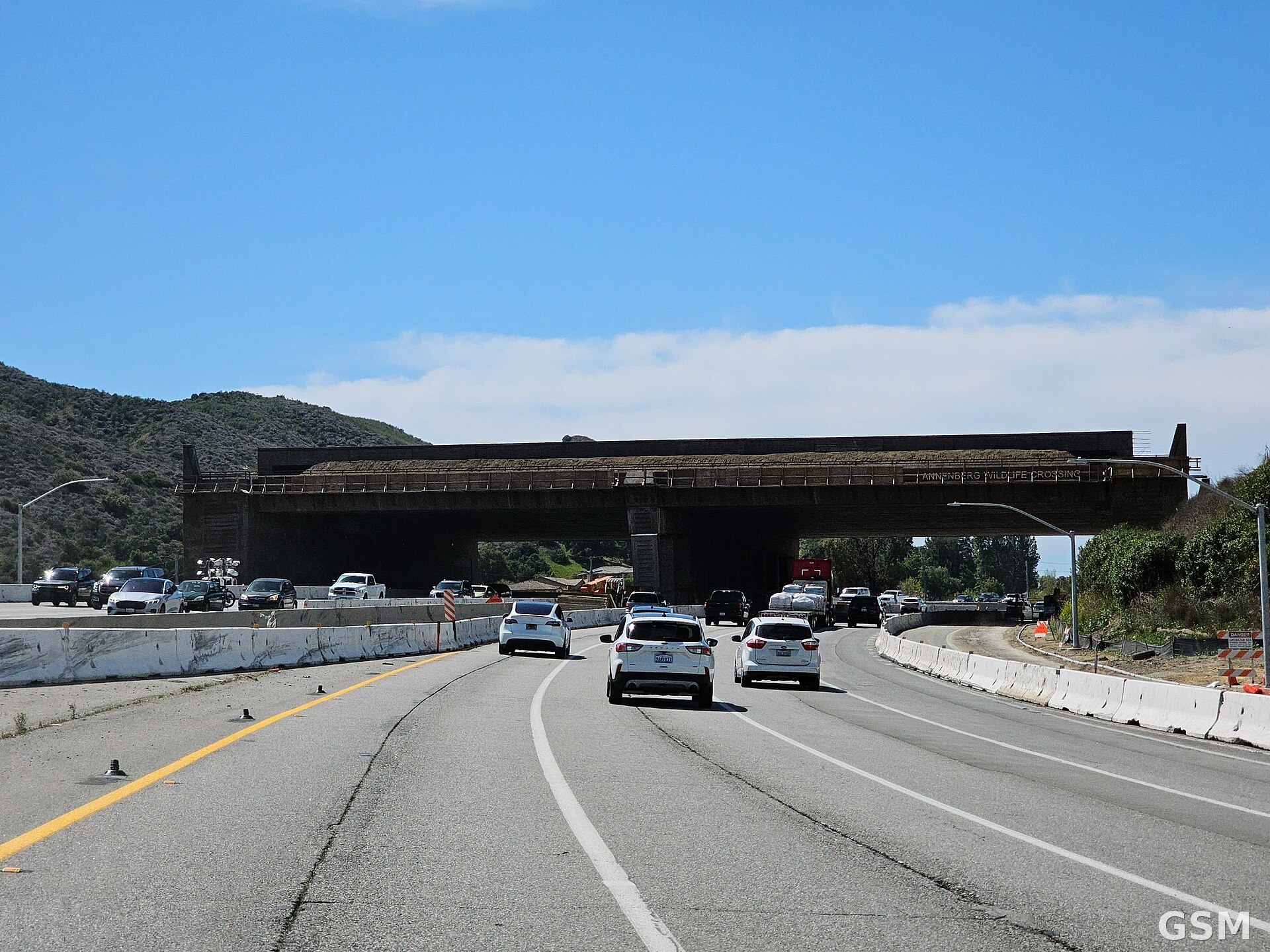
国家公园管理局(NPS)11月4日宣布,Santa Monica Mountains 国家休闲区的生物学家将于11月初在 Wallis Annenberg 野生动物通道安装远程野生动物相机,记录动物如何使用这座地标性通道。这座植被覆盖的跨线桥横跨 101 号高速公路与相邻的 Agoura Road,位于加州洛杉矶县 Agoura Hills 的 Liberty Canyon 附近,意在重新连接被高速公路分隔数十年的野生动物种群。
管理局表示,相机将记录哪些物种接近并使用通道、它们在何时使用,以及野生动物对 Santa Monica Mountains 与北部 Simi Hills 之间这条新连接的反应。相机监测只是科学家长期评估通道成效的多种方法之一,拍到的野生动物影像将对外公开,但出于安全考虑不做实时发布。
这项安装是管理局生物学家、项目伙伴与其他研究者共同制定的更广泛科学监测计划的一部分,框架共设 14 项目标,从记录美洲狮、骡鹿等野生动物的使用情况,到评估遗传多样性、植被群落、光线与声音等生态功能指标的变化。管理局野生动物部门负责人 Seth Riley 说:「这不只是动物会不会用这条通道的问题。我们想弄清它在重新连接一个被高速公路分隔数十年的生态系统方面到底有多有效,那是一个大得多的科学问题,回答它需要数年时间。」
管理局自 1996 年起就在 Santa Monica Mountains 地区研究野生动物与栖息地破碎化问题,记录高速公路与城市开发如何限制动物迁徙与基因流动,这项研究为通道的建设提供了科学基础。施工前监测已建立重要基线,包括对大型哺乳动物的 GPS 追踪、附近其他潜在通道地点的监测,以及小型脊椎动物的遗传研究。
10月28日,科学家拍到第一只登上未完工通道的动物,一只郊狼爬上了通道南坡;近期施工监测中,公园科学家还观察到短尾猫、郊狼、灰狐、骡鹿与美洲狮经常使用通道旁的一条小径。这座通道由国家野生动物联合会、Mountains Recreation and Conservation Authority、加州交通局(Caltrans)与国家公园管理局等州、联邦与非营利伙伴共同推进,跨越的高速公路日车流量超过 30 万辆。通道定于 12月2日正式向野生动物开放。
关联:郊狼抢先登上101号公路野生动物通道桥面:正式开通前近一个月被相机拍到
(来源:国家公园管理局)
Follow-Up: Park Service Launches Scientific Monitoring at Wallis Annenberg Wildlife Crossing, Set to Open to Wildlife on December 2
The National Park Service (NPS) announced on November 4 that biologists at Santa Monica Mountains National Recreation Area will install remote wildlife cameras in early November at the Wallis Annenberg Wildlife Crossing to document how animals use the landmark structure. The vegetated overpass spans the 101 Freeway and adjacent Agoura Road near Liberty Canyon in Agoura Hills, Los Angeles County, California, and is intended to reconnect wildlife populations separated for decades by the freeway.
The cameras will document which species approach and use the crossing, when they use it and how wildlife responds to the new connection between the Santa Monica Mountains and the Simi Hills to the north, the agency said. Camera monitoring will be one of several methods scientists use to evaluate the crossing's effectiveness over time, and images of wildlife using the crossing will be publicly available, though not in real time for security purposes.
The installation is part of a broader scientific monitoring program developed by Park Service biologists, project partners and other researchers, with a framework of 14 objectives ranging from documenting use by mountain lions, mule deer and other wildlife to evaluating changes in genetic diversity, vegetation communities, light and sound and other measures of ecological function. "This is more than just about whether animals use the crossing," said Seth Riley, the wildlife branch lead at Santa Monica Mountains National Recreation Area. "We want to understand how effective it is in reconnecting an ecosystem that has been divided by the freeway for decades. That is a much bigger scientific question and answering it will take years."
Park biologists have studied wildlife and habitat fragmentation in the region since 1996, documenting how freeways and urban development restrict wildlife movement and gene flow, work that provided the scientific foundation for the crossing. Pre-construction monitoring has established a baseline that includes GPS tracking of larger mammals, monitoring of other potential crossing locations nearby and genetic studies of smaller vertebrates.
On October 28, scientists captured the first photo of an animal on the unfinished crossing, a coyote climbing its southern slope, and during recent construction monitoring park scientists observed bobcats, coyotes, gray foxes, mule deer and mountain lions regularly using a trail immediately adjacent to the future crossing. The project is led by state, federal and nonprofit partners including the National Wildlife Federation, the Mountains Recreation and Conservation Authority, Caltrans and the National Park Service, across a freeway that carries more than 300,000 vehicles a day. The crossing is scheduled to officially open to wildlife on December 2, 2026.
(Source: National Park Service)
来源:国家公园管理局
发布:GSM·美国(发布链接)
图片来源:图:建设中的 Wallis Annenberg 野生动物通道横跨 101 号高速公路(2025年4月摄,资料图)。AragonChristopherR17Z 摄,CC BY-SA 4.0,经 Wikimedia Commons。/ The Wallis Annenberg Wildlife Crossing under construction over the 101 Freeway in April 2025 (file photo). Photo by AragonChristopherR17Z, CC BY-SA 4.0, via Wikimedia Commons.
GSM Global · 本篇英文版 English edition of this story
- 2026-11-05 20:22郊狼抢先登上101号公路野生动物通道桥面:正式开通前近一个月被相机拍到
- 2026-11-08 17:26跟进:国家公园管理局启动 Annenberg 野生动物通道科学监测 远程相机记录动物使用 12月2日正式开放本篇