思韦茨冰川融化比此前预估更猛烈 本世纪海平面贡献或翻倍至1.2英寸——研究10月12日发表
据CNN 10月15日报道,一支冰川学家团队的研究显示,位于西南极洲、被称作「末日冰川」的思韦茨冰川(Thwaites Glacier)融化速度比此前预估「更猛烈」(more aggressively),其对全球海平面上升的影响可能是当前估计的两倍。该研究于10月12日发表于《自然·通讯》(Nature Communications)。
思韦茨冰川面积约与美国佛罗里达州相当,是地球上最宽的冰川,数十年来持续退缩,目前其融冰约占全球海平面上升的4%。CNN称,该冰川若完全崩塌,所含水量足以使海平面上升2英尺以上;由于它还像瓶塞一样挡住南极冰盖,其消融最终可能导致约10英尺的海平面上升。
加州大学尔湾分校与美国国家航空航天局喷气推进实验室(NASA JPL)的冰川学家构建了一个新的冰盖模型。研究第一作者 Mattia Poinelli(现为加州大学洛杉矶分校项目科学家、研究期间任职于加州大学尔湾分校地球系统科学)表示,卫星数据显示,冰川的「接地线」实际上是一个数英里宽的「接地带」,海水随潮汐不断进出、抬升和压低厚冰层,这一过程被称作「潮汐泵送」(tidal pumping),使相对温暖的海水得以「深入冰盖之下、造成剧烈融化」。
把接地带概念纳入模型后,研究人员发现,即使全球变暖不再加剧,思韦茨冰川到2100年也可贡献最高1.2英寸的海平面上升,是此前估计的两倍。研究还发现,接地带的融化过程正加速冰体脱离一座名为穆日诺海脊(Mouginot Ridge)的大型水下山脊——该冰川在本世纪末前脱离这座山脊的概率为60%,其后冰川可能沿下倾的基岩快速退缩。
报告作者、加州大学尔湾分校地球系统科学教授 Eric Rignot 表示,研究结果「预示未来几十年沿海洪水风险与暴露程度将高于此前预期」,团队计划2028年前往当地部署仪器,记录海水进出。未参与研究的科罗拉多大学博尔德分校高级研究科学家 Ted Scambos 称,这一发现对思韦茨海平面预测可能是「真正的改变者」;同样未参与研究的英国南极调查局海洋地球物理学家 Robert Larter 则提醒,接地带过程仍有许多未知,需要获取冰川下方的直接数据。(GSM 据 CNN 报道,研究2026年10月12日发表于《自然·通讯》)
Thwaites Glacier Is Melting More Aggressively Than Projected, Study Published Oct. 12 Finds; Its Sea-Level Contribution by 2100 Could Double to 1.2 Inches
The Thwaites Glacier in West Antarctica — nicknamed the Doomsday Glacier — is melting "more aggressively" than previously projected, and its impact on global sea-level rise could be double current estimates, according to research by a team of glaciologists reported by CNN on October 15. The findings were published on October 12 in Nature Communications.
The Florida-sized glacier, the widest on Earth, has been retreating for decades, and its melting ice currently contributes around 4% to global sea-level rise. Thwaites holds enough water to raise sea levels by more than 2 feet if it were to collapse, and because it acts as a cork holding back the Antarctic ice sheet, its loss could ultimately lead to around 10 feet of sea-level rise, CNN said.
Glaciologists from the University of California, Irvine and NASA's Jet Propulsion Laboratory developed a new ice-sheet model. Lead author Mattia Poinelli, a project scientist at UCLA who was an Earth system science researcher at UC Irvine at the time of the study, said satellite data reveals the grounding line is actually a "grounding zone," sometimes miles wide, where seawater constantly flushes in and out with the tides in a process known as "tidal pumping," allowing relatively warm ocean water to penetrate "deep underneath the ice sheets and causing vigorous melting."
When the scientists adjusted the model to include a grounding zone, they found Thwaites could contribute up to 1.2 inches of sea-level rise by 2100 — twice previous estimates — even without further global warming. The study also found a 60% chance the glacier will become unpinned from the large underwater Mouginot Ridge by the end of the century, after which it is likely to retreat quickly.
Report author Eric Rignot, a professor of Earth system science at UC Irvine, said the results "predict greater risk of and exposure for coastal flooding than anticipated in the coming decades," and that the team plans to travel to Thwaites in 2028 to deploy instruments. Ted Scambos of the University of Colorado Boulder, who was not involved in the research, said the findings could be "a real gamechanger for sea level forecasting from Thwaites," while Robert Larter of the British Antarctic Survey, also not involved, cautioned that much remains unknown about grounding-zone processes and that direct data from underneath the glacier is needed. (GSM, reporting from CNN; study published Oct. 12 in Nature Communications)
发布:GSM·美国(发布链接)
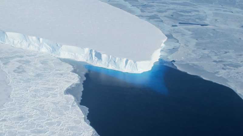
图片来源:思韦茨冰川(资料图)。图片来源:NASA / Wikimedia Commons,公共领域
GSM Global · 本篇英文版 English edition of this story