加州洪堡县外海发生7.0级地震:海啸警报约70分钟后解除
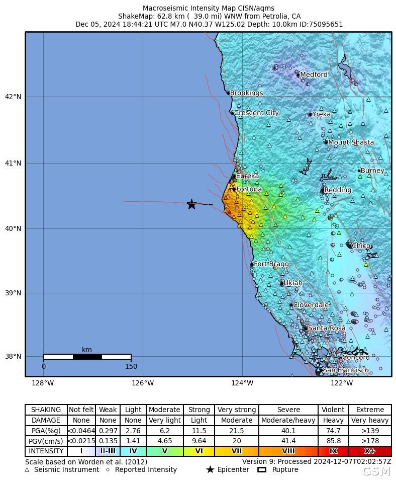
美国加利福尼亚州洪堡县(Humboldt County)外海12月5日上午发生7.0级地震。美国地质调查局(USGS)记录,地震发生于当地时间10时44分21秒,震中位于 Ferndale 以西约70公里的门多西诺三联点(Mendocino Triple Junction)以西海域。
美国国家海啸预警中心在地震后5分钟内、依据初步测得的7.3级发布了海啸警报,警报范围从加州 Davenport 向北延伸至俄勒冈州中部海岸。USGS 随后将震级修订为7.0级,并判定断层为走滑型。预警中心出于对海底滑坡的谨慎考虑维持警报,约70分钟后解除警报。
美国国家海洋和大气管理局(NOAA)的海啸科学与技术顾问小组复盘报告指出,门多西诺县 Arena Cove 验潮站记录到振幅约10厘米的小型海啸,未收到海啸造成损害或陆地淹没的报告。
USGS 在震后次日于 Eel River Valley、Cape Mendocino 与101号公路沿线布设了114台节点地震仪。USGS 的数据发布称,联合台网在此后约五周内记录到295次2.5级以上余震,其中14次超过4.0级。(来源:美国地质调查局)
Magnitude 7.0 Earthquake Strikes Off Humboldt County, California: Tsunami Warning Lifted After About 70 Minutes
A magnitude 7.0 earthquake struck off the coast of Humboldt County, California, on the morning of December 5. The U.S. Geological Survey (USGS) recorded the quake at 10:44:21 a.m. local time, with its epicenter about 70 kilometers southwest of Ferndale, just west of the Mendocino Triple Junction.
The U.S. National Tsunami Warning Center issued a tsunami warning within five minutes of the quake, based on a preliminary magnitude of 7.3; the warning area ran from Davenport, California, north to the central Oregon coast. The USGS later revised the magnitude to 7.0 and determined the faulting to be strike-slip. The warning center kept the warning in place out of caution over a possible submarine landslide, and canceled it about 70 minutes after the earthquake.
A post-event review by NOAA's Tsunami Science and Technology Advisory Panel reported that a tide gauge at Arena Cove in Mendocino County recorded a small tsunami of about 10 centimeters in amplitude, and that no tsunami damage or on-land flooding was reported.
Starting the next day, the USGS deployed 114 nodal seismometers in the Eel River Valley, near Cape Mendocino and along the California Highway 101 corridor. A USGS data release states that the combined network recorded 295 aftershocks of magnitude 2.5 or greater in the following five weeks, 14 of them above magnitude 4.0. (Source: U.S. Geological Survey)
来源:美国地质调查局
发布:GSM·美国(发布链接)
图片来源:图:美国地质调查局(USGS)本次地震 ShakeMap 烈度图(事件编号 75095651),公共领域。 / Photo: USGS ShakeMap intensity map for this earthquake (event ID 75095651), public domain.
GSM Global · 本篇英文版 English edition of this story