四场大气河流接连登陆太平洋西北地区:奥林匹克半岛降雨可达7英寸
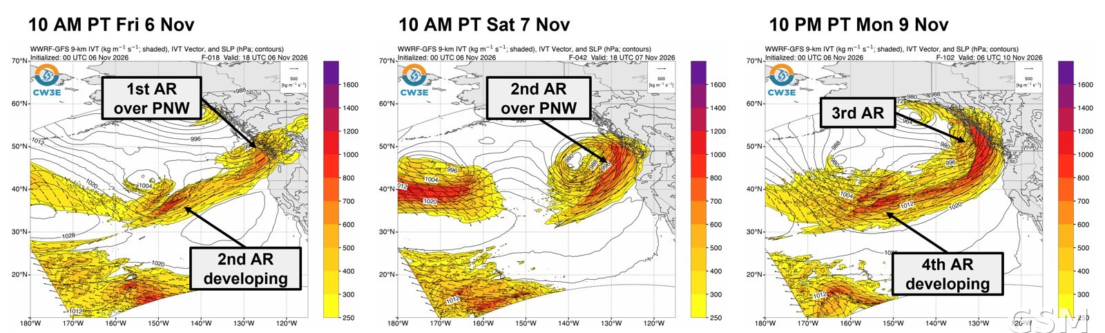
太平洋西北地区正迎来一轮接一轮的湿暖气流。加州大学圣迭戈分校斯克里普斯海洋研究所西部天气与水极端事件中心(CW3E)11月6日发布的大气河流展望说,一场中等强度的大气河流已于11月5日(周四)登陆加拿大不列颠哥伦比亚省和美国太平洋西北地区,第二场更强的大气河流紧随其后,于11月7日(周六)至8日影响同一地区,第三场和第四场预计分别在11月9日和10日抵达,首尾相接形成一段持续时间很长的湿润天气。
雨量方面,美国国家气象局天气预报中心预计,前两场大气河流将给华盛顿州奥林匹克半岛和北喀斯喀特山脉带来2至4英寸降雨;第三、第四场合计将给奥林匹克半岛和喀斯喀特山脉带来3至7英寸降雨,俄勒冈州南部克拉马斯山脉1.5至2.5英寸,华盛顿州、俄勒冈州和北加州沿海普遍0.5至1.5英寸。CW3E的集合预报工具显示,11月13日至15日太平洋西北和北加州再现大气河流活动的概率达70%至90%。
洪水风险目前总体偏低。美国国家海洋和大气管理局与国家气象局的水文集合预报服务显示,未来10天华盛顿州只有10个水文站有10%的概率超过警戒水位、1个站有10%的概率超过小洪水水位;不过华盛顿州北部的 Stehekin 河未来10天超过小洪水水位的概率达34%、超过警戒水位的概率达63%。
由于冻结层高度维持在约5000英尺,这几场大气河流的降水在流域内主要以雨的形态落下,只有最高海拔处例外。国家气象局气候预测中心还提示,11月13日至15日华盛顿州西部、俄勒冈州和北加州北部有强降水和沿海大风风险,南喀斯喀特山脉和内华达山脉有大雪风险。(来源:加州大学圣迭戈分校斯克里普斯海洋研究所)
Four Atmospheric Rivers in a Row Aim at the Pacific Northwest, With Up to 7 Inches of Rain on the Olympic Peninsula
The Pacific Northwest is in the middle of a parade of atmospheric rivers. In its atmospheric river outlook issued November 6, the Center for Western Weather and Water Extremes (CW3E) at UC San Diego's Scripps Institution of Oceanography said a moderate-strength atmospheric river made landfall over British Columbia and the Pacific Northwest on Thursday, November 5, to be followed by a second, stronger one on Saturday, November 7 into Sunday, November 8, with a third forecast to begin Monday, November 9 and a fourth on Tuesday, November 10, producing a long-duration period of atmospheric river conditions.
On rainfall, the National Weather Service's Weather Prediction Center forecasts 2 to 4 inches over Washington's Olympic Peninsula and the far northern Cascades from the first two atmospheric rivers. The third and fourth together are forecast to bring 3 to 7 inches over the Olympic Peninsula and the Cascades, 1.5 to 2.5 inches in the Klamath Mountains, and 0.5 to 1.5 inches broadly over coastal Washington, Oregon and Northern California. CW3E's ensemble landfall tools put the probability of further atmospheric river activity over the Pacific Northwest and Northern California on November 13-15 at 70 to 90 percent.
Flood risk is currently low overall. The NOAA and National Weather Service Hydrologic Ensemble Forecast Service shows only 10 gages in Washington with a 10 percent chance of exceeding action stage and one gage with a 10 percent chance of exceeding minor flood stage over the next 10 days. The Stehekin River in northern Washington, however, has a 34 percent probability of exceeding minor flood stage and a 63 percent probability of exceeding action stage over that period.
With freezing levels staying near 5,000 feet, precipitation from these atmospheric rivers is expected to fall mainly as rain across the watersheds, except at the highest elevations. The National Weather Service Climate Prediction Center has also highlighted risks of heavy precipitation and coastal high winds over western Washington, Oregon and northern California on November 13-15, with heavy snow possible in the southern Cascades and the Sierra Nevada. (Source: Scripps Institution of Oceanography, UC San Diego)
来源:加州大学圣迭戈分校斯克里普斯海洋研究所
发布:GSM·美国(发布链接)
图片来源:图:西部天气与水极端事件中心(CW3E)11月6日大气河流展望所附预报图。加州大学圣迭戈分校斯克里普斯海洋研究所 CW3E。 / Image: Forecast graphic from CW3E's November 6 atmospheric river outlook. CW3E, Scripps Institution of Oceanography, UC San Diego.
GSM Global · 本篇英文版 English edition of this story