南德州周末迎强降雨:周日至周一局部雨量或达4至8英寸,天气预报中心发布超量降雨轻度风险
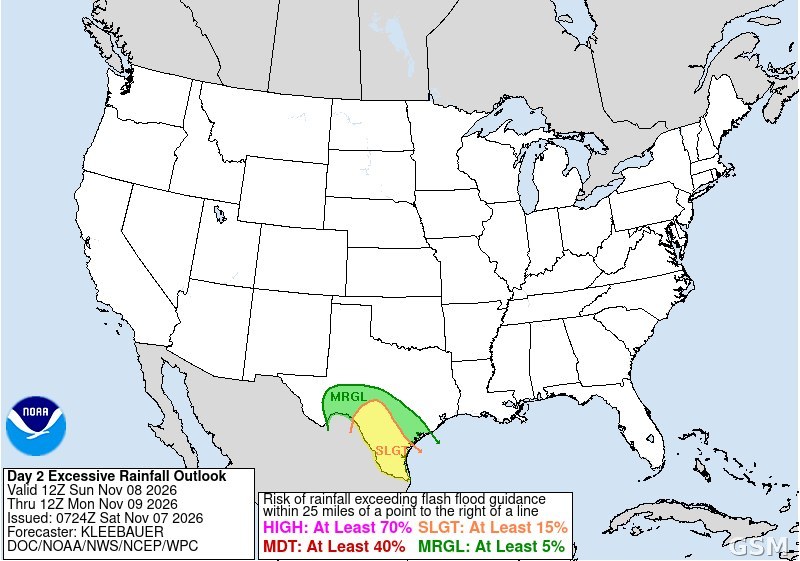
德克萨斯州南部本周末将迎来一轮强降雨,局部地区雨量可能达到 4 至 8 英寸,存在山洪风险。美国国家气象局天气预报中心已将德克萨斯州中南部与南部部分地区列入超量降雨轻度风险区(Slight Risk,4 级中的第 2 级),有效时间为 11 月 8 日星期日上午 6 时至 11 月 9 日星期一上午 6 时(中部时间)。
降雨系统自墨西哥方向移入。国家气象局奥斯汀/圣安东尼奥办公室预报,降雨于 11 月 7 日星期六夜间先在西部边境地区与大弯地区开始,随后于星期六向东扩散,星期六夜间至星期日全天为降雨最集中的时段,重点于星期日下午至晚间向南移动。预计全区平均雨量为 2 至 3 英寸,局部可达 4 至 8 英寸。AccuWeather 的分析认为,降雨最强的区域从圣安东尼奥与拉雷多附近至科珀斯克里斯蒂一带,向南延伸至布朗斯维尔。
星期六的降雨将先浸透地面,星期日的强降雨因此更难下渗,山洪风险随之升高。受影响的区域包括里奥格兰德平原、里奥格兰德河谷与海岸弯曲地区。风暴预测中心预报,11 月 7 日星期六与 11 月 8 日星期日全美无强对流雷暴预报区;德克萨斯州南部星期日可能出现零散至成片的非强对流雷暴。
全国天气形势方面,大部分地区本周在大型高压控制下保持干燥平静,降雨集中于太平洋西北部与德克萨斯州南部。太平洋西北部 11 月 7 日星期六夜间将迎来一股强冷锋,带来风雨,此后一周太平洋水汽将反复影响该地区。天气预报中心预计,从 11 月 10 日星期二起,东北太平洋将出现深槽,太平洋风暴路径趋于活跃。
加利福尼亚州方面,国家气象局尤里卡办公室 11 月 7 日凌晨 0 时 27 分发布的区域预报讨论说,德尔诺特县与洪堡县 11 月 7 日星期六夜间与 11 月 9 日星期一下午可能出现小雨;11 月 8 日至 10 日洪堡湾附近可能出现轻微至接近中度的沿海洪水,11 月 8 日星期日可能出现 20 至 25 英尺的破浪,恰逢特大潮。圣迭戈 11 月 7 日白天晴,最高气温 83 华氏度,降雨概率为 0。
Heavy Rain to Soak South Texas This Weekend: 4 to 8 Inches Possible Locally Sunday Into Monday
South Texas is in for a soaking weekend, with heavy rain and a risk of flash flooding on Saturday, November 7, and Sunday, November 8, 2026. The National Weather Service's Weather Prediction Center has placed parts of South Central and South Texas under a Slight Risk of excessive rainfall — level 2 of 4 — from 6 a.m. Sunday to 6 a.m. Monday, Central time.
A storm system moving in from Mexico is expected to drop 2 to 3 inches of rain across much of the region by Monday, with a few spots topping 5 inches and local totals of 4 to 8 inches possible, according to Texas Storm Chasers and the Weather Prediction Center. Rain starts Saturday night out west in the Borderland and Big Bend, then spreads east on Saturday, the National Weather Service office in Austin and San Antonio forecast, with widespread showers and storms from Saturday through Sunday night. The focus shifts south through Sunday afternoon and evening. AccuWeather says the risk may be greatest from near San Antonio and Laredo to Corpus Christi, stretching south to Brownsville.
Saturday's rain will soak the ground, so Sunday's downpours across the Rio Grande Plains, the Rio Grande Valley and the Coastal Bend will have nowhere to go, raising the flash-flood risk. The Storm Prediction Center forecasts no severe thunderstorms anywhere in the country Saturday or Sunday. Scattered to numerous non-severe storms are possible in southern, central and southwest Texas on Sunday.
Most of the country stays dry and quiet this week under a large high, while storms focus on the Pacific Northwest and South Texas. A strong cold front brings wind and rain to the Pacific Northwest on Saturday night, followed by repeated Pacific moisture plumes all week. From Tuesday on, the Weather Prediction Center expects "an active Pacific storm track" with deep troughing in the northeast Pacific.
In California, the National Weather Service office in Eureka said in an area forecast discussion issued at 12:27 a.m. PST on Saturday, November 7, that light rain is possible Saturday night and again Monday afternoon in Del Norte and Humboldt counties, that minor to near-moderate coastal flooding is likely around Humboldt Bay from November 8 to 10, and that breaking waves of 20 to 25 feet are expected Sunday and may coincide with a very high tide. San Diego is sunny on Saturday, November 7, with a high of 83 degrees Fahrenheit and a 0 percent chance of rain.
来源:美国国家气象局
发布:GSM·美国(发布链接)
图片来源:图:美国国家气象局天气预报中心11月7日发布的第2日超量降雨展望图,南德州为轻度风险区(黄色)。The NWS Weather Prediction Center Day 2 Excessive Rainfall Outlook issued Nov. 7, showing a Slight Risk over South Texas. (NOAA/NWS/WPC)
GSM Global · 本篇英文版 English edition of this story