国家海洋和大气管理局宣布西太平洋观测首例:两架海军水下滑翔机10月在超强台风Choi-Wan下方采集数据
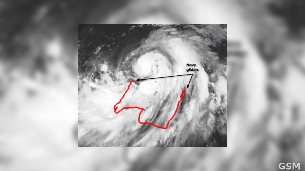
国家海洋和大气管理局(NOAA)的综合海洋观测系统(IOOS)宣布,2026年10月,两架美国海军水下滑翔机在超强台风 Choi-Wan 下方航行采样,在台风经过 Guam 附近海域之前、期间与之后收集水下数据。这是 NOAA 首次在西太平洋一场大型风暴的正下方获得水下海洋滑翔机数据,IOOS 称之为一项历史性里程碑。
据 IOOS 介绍,这项成果由 IOOS 协调的合作机制促成,参与方包括美国海军、NOAA 与 IOOS 区域协会伙伴,由其部署滑翔机并将数据提供给 NOAA 用于预报。自主滑翔机能够深潜,实时测量海水温度与盐度;由于热带气旋的能量来自温暖海水,水下数据对预报至关重要,有助于预报模型更好地预测风暴强度与快速增强,让沿海与岛屿社区获得更及时的警报与信息。
自2018年以来,美国海军一直是 IOOS 主导的飓风滑翔机协调行动的关键伙伴,与该团队合作在美国水域部署滑翔机,采集用于预报模型的上层海洋观测数据。2026年,海军与 NOAA 的合作扩展到太平洋水域,Guam 水域迎来首批滑翔机,并在合作的第一年即在该海域实现这一里程碑。
NOAA Announces a Western Pacific First: Two Navy Underwater Gliders Gathered Data Directly Beneath Super Typhoon Choi-Wan in October
The U.S. Integrated Ocean Observing System (IOOS), part of the National Oceanic and Atmospheric Administration (NOAA), has announced that in October 2026 two U.S. Navy underwater gliders flew beneath Super Typhoon Choi-Wan, gathering underwater data near Guam before, during and after the storm's passage. It marks the first time that underwater ocean glider data was gathered for NOAA directly beneath a major storm in the western Pacific, a milestone IOOS described as historic.
According to IOOS, the milestone was made possible through a partnership it coordinates, bringing together the U.S. Navy, NOAA and IOOS Regional Association partners to deploy gliders and make their data available to NOAA for forecasts. Autonomous gliders dive deep to collect real-time measurements of ocean temperature and salinity. Because tropical cyclones draw their power from warm waters, underwater glider data is critical to helping forecast models better predict storm intensity and potential rapid intensification, giving coastal and island communities more timely warnings and information.
Since 2018, the Navy has been a key partner in the IOOS-led hurricane glider coordination effort, deploying gliders in U.S. waters to gather the upper-ocean observations used in forecasting models. In 2026, the Navy-NOAA partnership expanded into Pacific waters, including the first gliders in Guam waters, achieving this milestone in its first year there.
来源:GSM·美国(原文链接)
图片来源:图:超强台风 Choi-Wan 的卫星云图与两架海军水下滑翔机在 Guam 附近海域的航迹(红线),为 NOAA IOOS 原文配图。卫星图:NOAA/NCEP 全球合并红外卫星图,航迹数据:IOOS Glider DAC,美国联邦政府作品,公共领域 / Satellite image of Super Typhoon Choi-Wan with the tracks (red) of two Navy gliders near Guam, the illustration from the NOAA IOOS story. Satellite: NOAA/NCEP Global Merged IR image; tracks: IOOS Glider DAC, U.S. federal government work, public domain. Source: https://ioos.noaa.gov/news/milestone-western-pacific-glider-data/