大潮为何破纪录:洛杉矶港潮位创有记录以来最高 迈阿密连续6天超中度洪水线 外滩群岛公路被冲毁
10 月 26 日满月前后,破纪录的大潮同时席卷美国东西海岸:加州洛杉矶港潮位创下该站有记录以来的最高纪录,佛罗里达迈阿密连续 6 天超过中度洪水线,北卡罗来纳外滩群岛的沿海公路被海水冲毁、哈特拉斯岛游客撤离令仍在执行。这不是一场风暴,而是一次天文大潮、厄尔尼诺与偏暖海水、近海风浪叠加的结果;气象部门警告,南加州的显著沿海洪水将持续至 10 月 29 日周四,佛罗里达的最高潮预计出现在 10 月 27 日周二上午。
一、“大潮”是什么
“大潮”(king tide)并非科学术语。美国国家海洋和大气管理局(NOAA)的解释是:它是对一年中异常偏高潮位的通俗叫法,通常出现在新月或满月、且月球运行至近地点(离地球最近点)时,再叠加季节因素。美国国家气象局天气预报中心气象学家鲍勃·奥拉韦茨对 10 月 26 日这次的解释是:满月、偏暖海水、厄尔尼诺现象、近海风暴等多种因素叠加,推高了季节性大潮。迈阿密大学海洋与大气科学学院高级研究助理布赖恩·麦克诺尔迪补充了时间点:10 月 26 日是满月,10 月 28 日是近地点。
二、西海岸:洛杉矶港百年纪录
加州是这次大潮破纪录最集中的地方。洛杉矶港圣佩德罗验潮站 10 月 26 日上午高潮位初值 8.02 英尺,《今日美国》称“略高于 8 英尺”,创下该站自 1923 年 11 月有记录以来的历史纪录;此前纪录为 2005 年 1 月 10 日的 7.93 英尺。洛杉矶与圣迭戈气象部门警告,南加州“显著沿海洪水”将持续至 10 月 29 日周四,潮位可能比正常满月预报高出多达 1.7 英尺,晨潮或超 8 英尺;拉霍亚 10 月 26 日晨潮至少达 7.79 英尺。
橙县的情况更具体:纽波特海滩 10 月 26 日高潮位达 8.3 英尺,海水涌上巴尔博亚半岛低洼街道;纽波特海滩警察局称,10 月 27 日周二高潮位预报为 8.5 英尺。水泵已经启动,沙丘堤坝已经布设,纽波特海滩暂停停车执法至 10 月 28 日周三晚,以便居民把车移出易涝区。橙县全岸的海岸洪水警告与洛杉矶县海岸的海岸洪水提示均持续至 10 月 29 日周四下午 1 点;气象部门称,橙县潮位比天文预报高出 1 至 1.7 英尺,洛杉矶县海岸高出 1 至 1.5 英尺。
三、佛罗里达:迈阿密的 10 天
迈阿密的纪录不是一天,而是一串。麦克诺尔迪称,截至 10 月 26 日周一,迈阿密弗吉尼亚礁验潮站已连续 6 天超过“中度洪水”阈值;按迈阿密大学的潮汐预报模型,这轮超标可能达到“史无前例的 10 天”才回落,最高峰预计在 10 月 27 日周二上午 10 点 30 分。10 月 25 日的纪录是过去 5 天内的第 4 次破纪录,也是该站历史第五高水位。卡纳维拉尔港的高潮位则是该站自 1994 年 10 月设立以来最高的非热带气旋相关水位。
佛罗里达东岸的警告覆盖面很广:南佛罗里达(布劳沃德与迈阿密-戴德)海岸洪水警告从 10 月 26 日周一凌晨 2 点持续至 10 月 28 日周三晚 8 点,棕榈滩至迈阿密-戴德一带阵风达 46 英里、浪高 12 至 15 英尺;棕榈滩县警告持续至周三晚 8 点,伴随 8 至 13 英尺的破浪;太空海岸警告持续至 10 月 29 日周四凌晨 2 点,伴随 7 至 11 英尺的破浪;佛罗里达礁岛群的海岸洪水提示持续至 10 月 31 日。劳德代尔堡与迈阿密滩均已报告洪水。
四、外滩群岛:公路断了
北卡罗来纳外滩群岛是这次大潮中基础设施受损最重的地方。北卡罗来纳州交通部称,12 号公路在马克·巴斯奈特大桥至罗丹斯段关闭,海浪摧毁了约 800 英尺路面、冲毁近 2000 英尺防护沙丘;工作人员正在皮岛游客中心一带重建 1800 多英尺沙丘、清除损毁路面并平整路基,但高潮漫滩仍是问题。戴尔县 10 月 23 日中午的通报称,皮岛游客中心一带的漫滩持续到当日晨潮,南行车道又出现新的路面损毁;公路重开没有确定的时间表。
哈特拉斯岛的游客强制撤离令仍在执行,游客不得进入该岛;北卡罗来纳州交通部轮渡部门已开通斯汤普点至罗丹斯的 24 小时应急轮渡,仅限持证的常住居民、业主、应急人员与关键物资供应商通行。北卡罗来纳州州长乔希·斯坦已宣布戴尔县与海德县进入紧急状态,并要求联邦公路管理局支持抢修与长期解决方案。
这已经是外滩群岛不到一个月内第二次遭受重创:9 月 24 日一场强沿海风暴曾导致 12 号公路在戴尔县段严重损毁、关闭至 9 月 29 日才恢复北向通行;10 月 16 日第二场风暴再次造成损毁并暂停轮渡;10 月 20 日前后的秋季东北风暴与随后的亚热带风暴“约瑟芬”又把公路冲断。
五、潮水背后的基线
大潮年年有,但基线在抬高。麦克诺尔迪指出,迈阿密地区的海平面较 NOAA 采用的 1983 至 2001 年基线已上升 6.5 英寸。迈阿密-戴德县政府的说法是:海平面上升正在使这类潮水更频繁、持续更久、向内陆延伸更远。按迈阿密滩市依据 NOAA 弗吉尼亚礁站潮汐表公布的 2026 年大潮窗口,10 月 24 至 30 日这一轮过后,下一轮在 11 月 6 至 9 日,再下一轮在 11 月 23 至 26 日。
气象部门的后续时间点是:南加州显著沿海洪水持续至 10 月 29 日周四;圣迭戈气象部门称,按一组模式预测,万圣节周末南加州降雨概率可达正常值的 250%,潮水与降雨叠加可能加重低洼地区的积水与海滩侵蚀。外滩群岛公路重开时间未定,哈特拉斯岛游客限制不变。
关联:跟进:大潮破纪录席卷美国东西海岸:洛杉矶港潮位创历史纪录,外滩群岛公路损毁、游客撤离
Why the King Tides Broke Records: Los Angeles Harbor Hits All-Time High, Miami Spends Six Days Above Flood Level, Outer Banks Highway Destroyed
Around the full moon of October 26, record-breaking high tides slammed both coasts of the United States at once: Los Angeles Harbor set an all-time record at its gauge, Miami spent a sixth straight day above its moderate-flood threshold, and a coastal highway on North Carolina's Outer Banks was destroyed by ocean overwash while a visitor evacuation order on Hatteras Island remained in force. This was not a single storm. It was a seasonal astronomical high tide stacked with El Niño, warmer-than-normal waters, and onshore winds and surf. Forecasters warned that significant coastal flooding in Southern California would last through Thursday, October 29, and that Florida's highest tide of the event was expected on Tuesday morning, October 27.
1. What a "king tide" is
"King tide" is not a scientific term. The National Oceanic and Atmospheric Administration (NOAA) defines it as a popular name for exceptionally high tides, typically occurring at a new or full moon when the Moon is at perigee, its closest approach to Earth, combined with seasonal factors. Bob Oravec, a meteorologist with the National Weather Service Weather Prediction Center, attributed this event to a stack of factors: the October 26 full moon, warmer-than-normal waters, El Niño, and offshore storms, all pushing seasonal high tides higher. Brian McNoldy, a senior research associate with the University of Miami's Rosenstiel School of Marine, Atmospheric, and Earth Science, added the timing: full moon on October 26, perigee on October 28.
2. West Coast: the Los Angeles Harbor record
California produced the event's sharpest records. At San Pedro in Los Angeles Harbor, the high tide on the morning of October 26 reached a preliminary 8.02 feet — "just above 8 feet," as USA TODAY put it — an all-time record for a gauge whose records date back to November 1923. The previous record was 7.93 feet, set on January 10, 2005. The National Weather Service offices in Los Angeles and San Diego warned that "significant coastal flooding" in Southern California would last through Thursday, October 29, with tides forecast as much as 1.7 feet above normal full-moon predictions, likely raising morning high tides above 8 feet; the morning high tide at La Jolla on October 26 reached at least 7.79 feet.
Orange County's details are more concrete. Newport Beach recorded a high tide of 8.3 feet on October 26, with ocean water flooding low-lying streets on the Balboa Peninsula; the Newport Beach Police Department forecast a tide of 8.5 feet for Tuesday, October 27. Water pumps were activated and sand berms put in place, and the city suspended parking enforcement through Wednesday evening, October 28, so residents could move vehicles out of flood-prone areas. A coastal flood warning for the entire Orange County coastline and a coastal flood advisory for the Los Angeles County coastline both remained in effect until 1 p.m. Thursday, October 29. Forecasters said tides were running about 1 to 1.7 feet above astronomical predictions in Orange County and roughly 1 to 1.5 feet above predictions along the Los Angeles County coastline.
3. Florida: Miami's ten days
Miami's story is not one day but a streak. As of Monday, October 26, the Virginia Key tide gauge in Miami had exceeded its "moderate flooding" threshold for six consecutive days, McNoldy said. Under the University of Miami's tide forecast model, the streak could reach "an unprecedented 10 days" before water levels retreat, with the highest peak of the event expected at 10:30 a.m. on Tuesday, October 27. The record set on October 25 was the fourth record in five days and the fifth-highest tide ever recorded at the gauge. At Port Canaveral, a high tide was the highest non-tropical-cyclone-related water level ever recorded since the gauge was established in October 1994.
Warnings covered much of Florida's east coast. A coastal flood warning for South Florida (Broward and Miami-Dade) ran from 2:00 a.m. Monday, October 26, through 8:00 p.m. Wednesday, October 28, with gusts to 46 mph and waves of 12 to 15 feet from Palm Beach County through Miami-Dade County. Palm Beach County's warning ran through 8:00 p.m. Wednesday with 8-to-13-foot breaking waves; the Space Coast warning ran through 2:00 a.m. Thursday with 7-to-11-foot breaking waves; the Florida Keys remained under a coastal flood advisory through October 31. Flooding was reported in Fort Lauderdale and Miami Beach.
4. Outer Banks: the highway is gone
North Carolina's Outer Banks suffered the event's heaviest infrastructure damage. The North Carolina Department of Transportation closed Highway 12 between the Marc Basnight Bridge and Rodanthe after waves destroyed about 800 feet of pavement and wiped out nearly 2,000 feet of protective dunes. At the Pea Island Visitor Center, crews were rebuilding more than 1,800 feet of dunes, removing damaged pavement, and grading the roadbed, "but high tide overwash continues to be an issue," the department said. Dare County's noon update on October 23 said overwash at the Pea Island Visitor Center continued through that morning's high tide, with additional pavement damage in the southbound lane, and that there was no confirmed timeline for reopening the closed section.
A mandatory evacuation order for visitors on Hatteras Island remained in effect; visitors were not permitted to enter. The NCDOT Ferry Division began 24-hour emergency ferry service between Stumpy Point and Rodanthe, limited to credentialed permanent residents, property owners, emergency personnel, and critical supply vendors. Governor Josh Stein declared a state of emergency in Dare and Hyde counties and called on the Federal Highway Administration to support immediate repairs and long-term solutions.
This is the second punishing blow to the Outer Banks in less than a month. A strong coastal storm on September 24, 2026, caused significant structural damage to Highway 12 in Dare County, closing it until September 29, when it reopened to northbound traffic only. A second storm on October 16 caused additional damage and again suspended ferry service, and the autumn nor'easter around October 20, followed by Subtropical Storm Josephine, cut the highway again.
5. The baseline underneath the tide
King tides come every year, but the baseline is rising. McNoldy noted that sea level in the Miami area has risen 6.5 inches since the 1983–2001 baseline NOAA uses for tide measurements. Miami-Dade County's own assessment is that sea level rise is causing these tides to happen more frequently, to last longer, and to extend further inland than in the past. Under the City of Miami Beach's 2026 king-tide calendar, based on NOAA's Virginia Key tide tables, the next windows after October 24–30 are November 6–9 and November 23–26.
The official timelines going forward are: significant coastal flooding in Southern California through Thursday, October 29; the San Diego weather service office said one set of models put Halloween-weekend rainfall chances in Southern California at up to 250% of normal, which, stacked on elevated ocean levels, could worsen flooding in vulnerable coastal areas and speed up beach erosion. On the Outer Banks, no reopening timeline has been announced, and Hatteras Island's visitor restrictions remain unchanged.
Related: Follow-Up: Record King Tides Slam Both U.S. Coasts
来源:GSM·美国(原文链接)
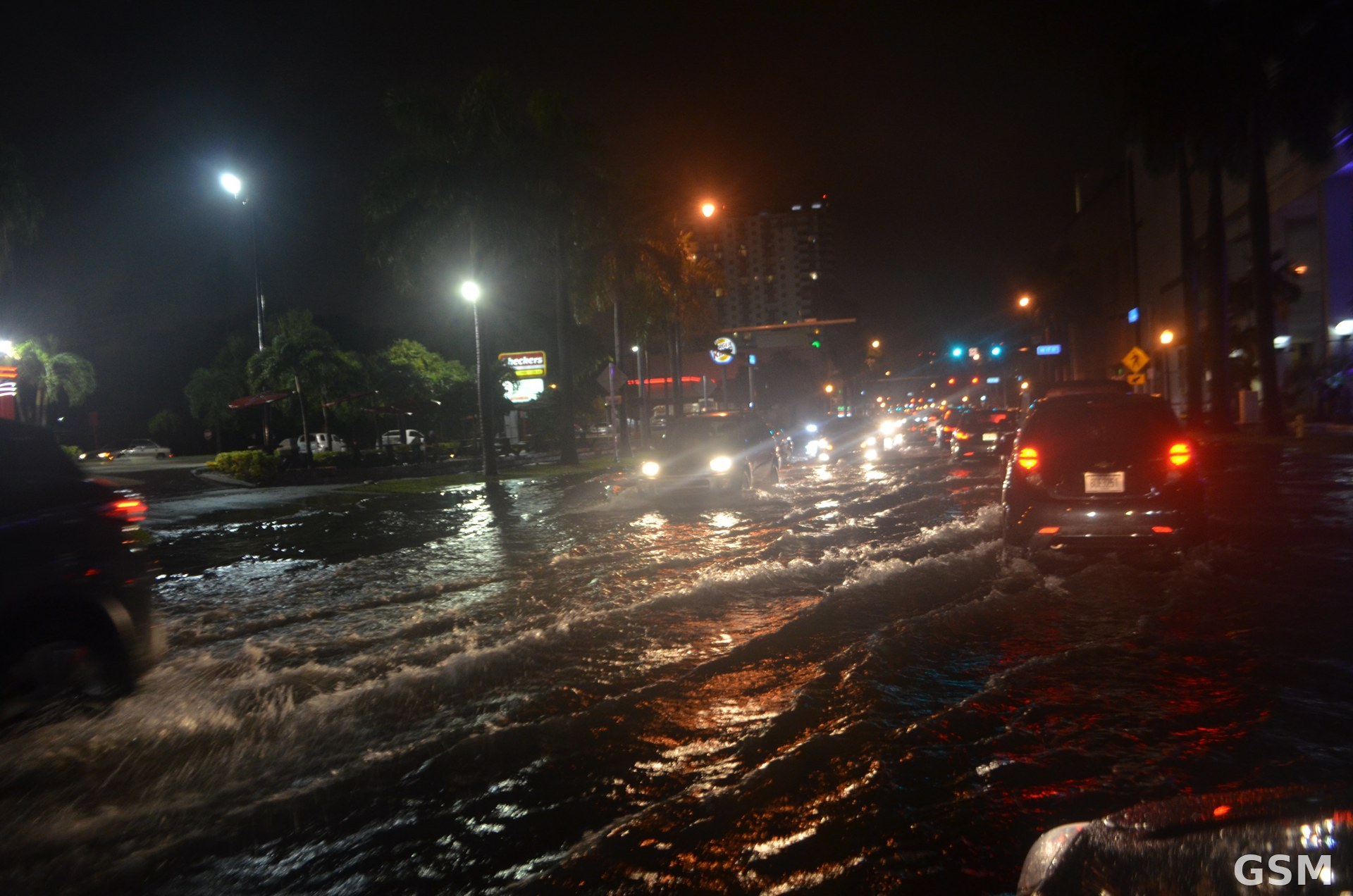
图片来源:迈阿密大潮淹水街景,Wikimedia Commons,CC0
- 2026-10-23 16:54Newport Beach 宣布本地紧急状态:迎 10 月 26 至 28 日 King Tides 大潮,三处地点可领免费沙袋
- 2026-10-24 04:26跟进:大潮洪水警告周日生效 橙县与San Diego县潮位或达8英尺 Metrolink下周停开海岸段
- 2026-10-25 22:22跟进:橙县大潮明起三天达峰值,Newport Beach 最高潮位或达8.5英尺,三处免费沙袋点持续开放
- 2026-10-26 01:44洛杉矶沿海大潮警告10月26日仍生效:潮位可达8英尺,低洼海滩路段注意积水
- 2026-10-26 17:45跟进:大潮破纪录席卷美国东西海岸:洛杉矶港潮位创历史纪录,外滩群岛公路损毁、游客撤离
- 2026-10-26 18:52大潮为何破纪录:洛杉矶港潮位创有记录以来最高 迈阿密连续6天超中度洪水线 外滩群岛公路被冲毁本篇