瓦努阿图近海发生6.9级地震:海啸威胁已经解除,暂无伤亡报告
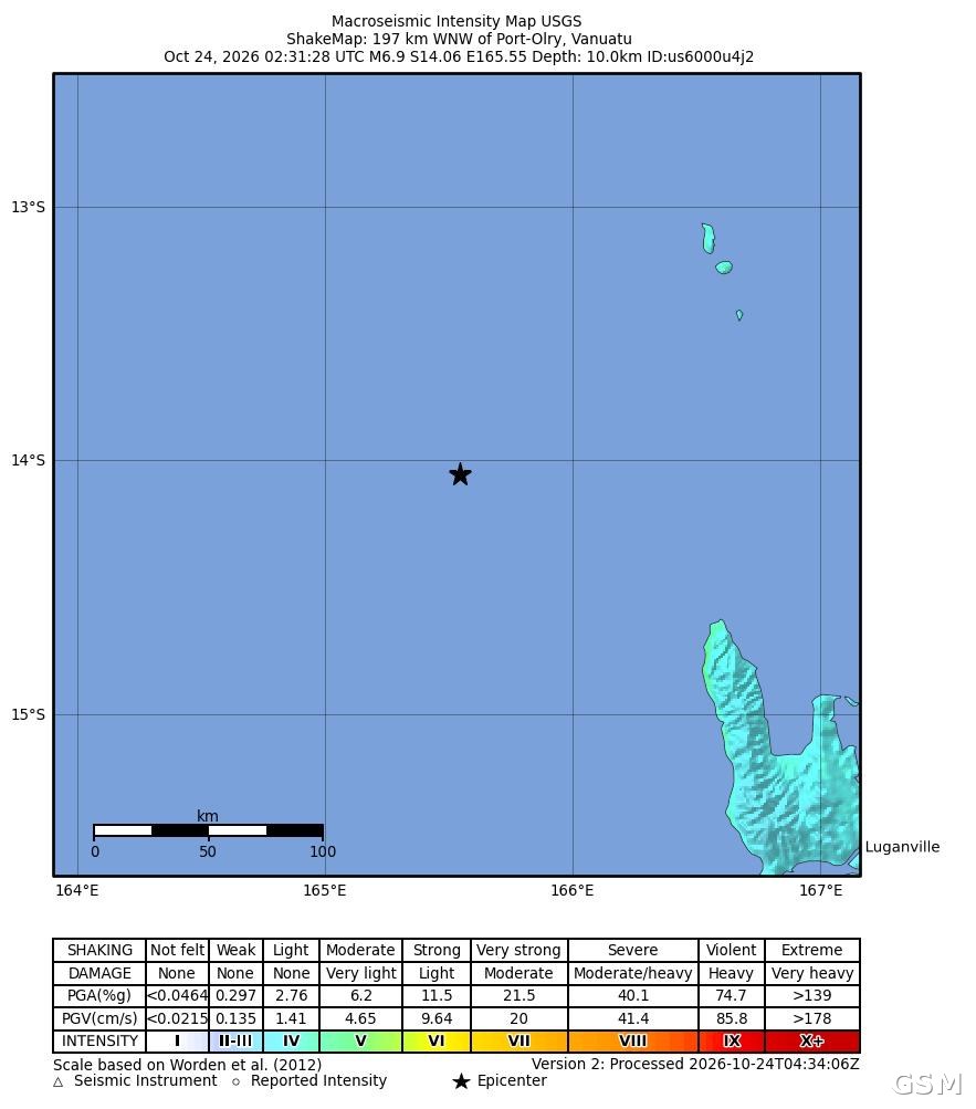
美国地质调查局(USGS)的数据显示,南太平洋岛国瓦努阿图近海10月24日发生6.9级地震,震中位于 Port-Olry 以西偏西北约197公里处,震源深度10公里。发震时间为协调世界时10月24日02时31分,即瓦努阿图当地时间13时31分、美国洛杉矶(Los Angeles)时间10月23日19时31分。USGS 最初公布的初步震级为7.2级,随后经复核修正为6.9级,本稿以复核数据为准。
太平洋海啸预警中心在地震后一度针对震中周边海域发布海啸威胁信息。该中心在协调世界时03时28分发布的后续通报中确认,海啸威胁已经过去;震中附近部分海岸在随后数小时内可能仍会出现轻微的海平面波动。截至发稿,当地尚未传出人员伤亡或财产损失的报告。
主震约4分钟后,同一海域再发生一次6.3级地震,震中位于 Port-Olry 以西北约170公里处,震源深度同样为10公里。USGS 对这两次地震均给出绿色预警级别,意为引发重大伤亡与损失的可能性较低;其中6.9级主震的仪器测定最大烈度约为5.1,该局已收到少量有感报告。
瓦努阿图位于太平洋火环带上,地处澳大利亚板块与太平洋板块交界附近,地震与火山活动频繁。当地有关部门与国际监测机构仍在评估震后情况,USGS 与太平洋海啸预警中心的后续更新将决定是否有余震与海况方面的进一步通报。
Magnitude 6.9 Earthquake Strikes off Vanuatu: Tsunami Threat Passes, No Casualties Reported So Far
Data from the U.S. Geological Survey (USGS) show that a magnitude 6.9 earthquake struck off the coast of the South Pacific island nation of Vanuatu on October 24, with its epicenter about 197 kilometers (122 miles) west-northwest of Port-Olry at a depth of 10 kilometers (6.2 miles). The quake occurred at 02:31 UTC on October 24, which is 13:31 local time in Vanuatu and 19:31 on October 23 in Los Angeles. The USGS initially put the preliminary magnitude at 7.2 before revising it to 6.9 after review; this report uses the reviewed figures.
The Pacific Tsunami Warning Center initially issued a tsunami threat message for coasts near the epicenter. In a follow-up bulletin issued at 03:28 UTC, the center confirmed that the tsunami threat had passed, while noting that minor sea-level fluctuations could still occur along some coasts near the epicenter over the following hours. As of publication, there were no reports of casualties or property damage.
About four minutes after the main shock, a second earthquake of magnitude 6.3 struck the same area, centered about 170 kilometers (106 miles) northwest of Port-Olry, also at a depth of 10 kilometers. The USGS assigned a green alert level to both earthquakes, indicating a low likelihood of significant casualties or damage. The maximum instrumental intensity recorded for the magnitude 6.9 main shock was about 5.1, and the agency received a small number of felt reports.
Vanuatu sits on the Pacific Ring of Fire, near the boundary between the Australian Plate and the Pacific Plate, where earthquakes and volcanic activity are frequent. Local authorities and international monitoring agencies are still assessing the situation, and further updates from the USGS and the Pacific Tsunami Warning Center will determine whether additional bulletins on aftershocks or sea conditions are issued.
来源:GSM·美国(原文链接)
图片来源:图:USGS 发布的本次地震震动图(ShakeMap),星标为震中位置,位于 Port-Olry 以西偏西北约197公里。图片:美国地质调查局 USGS,公共领域。