跟进:北加州Mendocino县「Cooley Fire」控制率升至90% 过火面积1,365英亩 现场71人继续守线
位于加利福尼亚州Mendocino县、Cloverdale以西Yorkville附近的「Cooley Fire」控制率已升至90%。加州消防局(CAL FIRE)10月24日下午4时29分在官方事故页更新中通报了这一最新控制率;过火面积仍为1,365英亩,现场投入人员仍为71人。
据CAL FIRE事故页10月24日上午8时42分的更新,消防员当天回到火线巡查热点、加固控制线并检查重点区域;事发地一带夜间预报有强风,队伍全天持续监测风况,并对可能受风影响的区域重新评估。
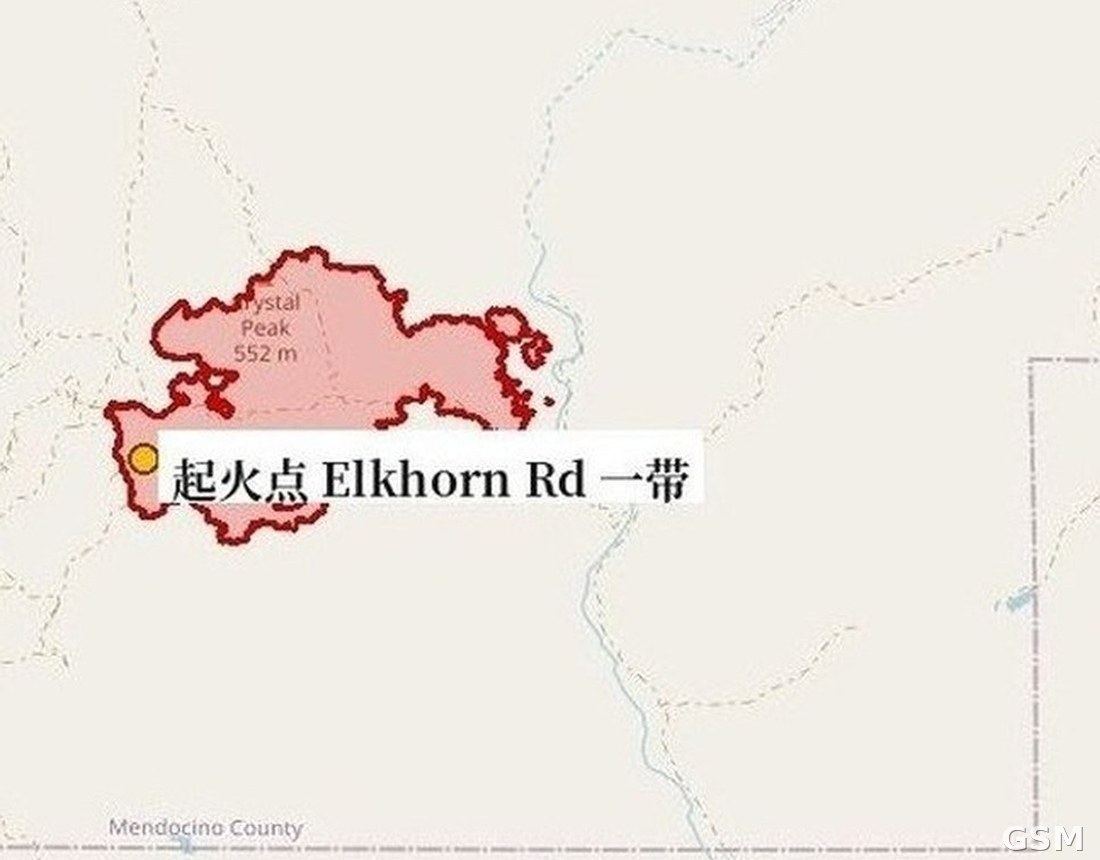
这场火灾于10月16日下午5时05分在Elkhorn Road与Cooley Ranch Road一带、即Cloverdale以西燃起,起火原因仍在调查中,由CAL FIRE Mendocino分队管辖。CAL FIRE此前表示,这起事故中没有建筑受损或被毁,历次官方更新均未发布疏散令,本次更新亦未提及疏散令变化。
本站此前报道,10月23日这场火的控制率升至86%,现场71名人员以无人机系统(UAS)支援地面队伍定位热点、扑灭余火。以上据加州消防局(CAL FIRE)官方事故页10月24日更新。
Update: Cooley Fire in Mendocino County Reaches 90% Containment at 1,365 Acres as 71 Personnel Hold the Line
The Cooley Fire, burning near Yorkville west of Cloverdale in Mendocino County, California, is now 90% contained. CAL FIRE reported the new containment figure in an incident update posted at 4:29 p.m. on October 24; the burned area remains 1,365 acres and personnel assigned remain 71.
In an update at 8:42 a.m. on October 24, CAL FIRE said firefighters would be back out on the line that day monitoring for hotspots, strengthening containment lines and checking areas of concern. High winds were forecast for the area overnight, and crews planned to keep monitoring wind conditions throughout the day and reassess areas where winds could affect containment.
The fire started at 5:05 p.m. on October 16 near Elkhorn Road and Cooley Ranch Road, west of Cloverdale. Its cause remains under investigation, and the incident is under the jurisdiction of the CAL FIRE Mendocino Unit. CAL FIRE has previously said no structures were damaged or destroyed in this incident, no evacuation orders have been issued in its official updates, and the latest update mentioned no evacuation changes.
GSM previously reported that the fire reached 86% containment on October 23, with 71 personnel using Uncrewed Aerial Systems (UAS) to support ground crews in locating hotspots. The above is based on CAL FIRE's official incident page updates of October 24.
来源:GSM·美国(原文链接)
图片来源:图:Cooley Fire态势图(GSM据加州消防局CAL FIRE/NIFC官方测绘周界绘制,本轮以新幅面重新裁切,制作于2026年10月24日)。图中红色周界为官方测绘的火场范围、黄点为起火点Elkhorn Rd一带;最新官方数据以正文为准:过火面积1,365英亩、控制率90%(CAL FIRE官方事故页10月24日下午4时29分更新)。底图 © OpenStreetMap contributors。 Situation map of the Cooley Fire, drawn by GSM from the official CAL FIRE/NIFC mapped perimeter (re-cropped this round with a new framing, prepared Oct. 24, 2026). The red perimeter is the officially mapped fire area and the yellow dot marks the origin near Elkhorn Rd. The latest official figures are in the text: 1,365 acres and 90% containment, per CAL FIRE's incident page update at 4:29 p.m. on Oct. 24. Base map © OpenStreetMap contributors.
- 2026-10-17 22:42北加州Mendocino县Cooley Fire过火面积升至731英亩 控制率仅5% 暂无疏散令
- 2026-10-18 16:24跟进:北加州Mendocino县「Cooley Fire」重测过火面积1,036英亩 控制率升至15%
- 2026-10-18 22:49跟进:北加州Mendocino县「Cooley Fire」过火面积升至1,156英亩 控制率15%
- 2026-10-19 08:30跟进:北加州Mendocino县「Cooley Fire」控制率升至23% 过火面积仍为1,156英亩
- 2026-10-19 14:50跟进:北加州Mendocino县「Cooley Fire」过火面积升至1,364英亩 控制率仍为23%
- 2026-10-19 18:10跟进:北加州Mendocino县「Cooley Fire」控制率升至45% 过火面积1,364英亩
- 2026-10-20 01:14跟进:Mendocino县「Cooley Fire」开始火场修护 内部未燃区未见明火、建筑无损
- 2026-10-20 15:47跟进:北加州Mendocino县「Cooley Fire」控制率升至57% 过火面积1,365英亩
- 2026-10-20 18:01跟进:北加州Mendocino县「Cooley Fire」控制率升至67% 过火面积1,365英亩 队伍开始回收火线装备
- 2026-10-23 00:21跟进:北加州Mendocino县「Cooley Fire」控制率升至80% 过火面积1,365英亩 指挥权移交本地分队
- 2026-10-24 02:28跟进:北加州Mendocino县「Cooley Fire」控制率升至86% 过火面积1,365英亩 现场71人继续清热点
- 2026-10-24 16:38跟进:北加州Mendocino县「Cooley Fire」控制率升至90% 过火面积1,365英亩 现场71人继续守线本篇