跟进:河滨县「Viper Fire」蔓延已遏止 过火0.5英亩 消防员留守清理余火
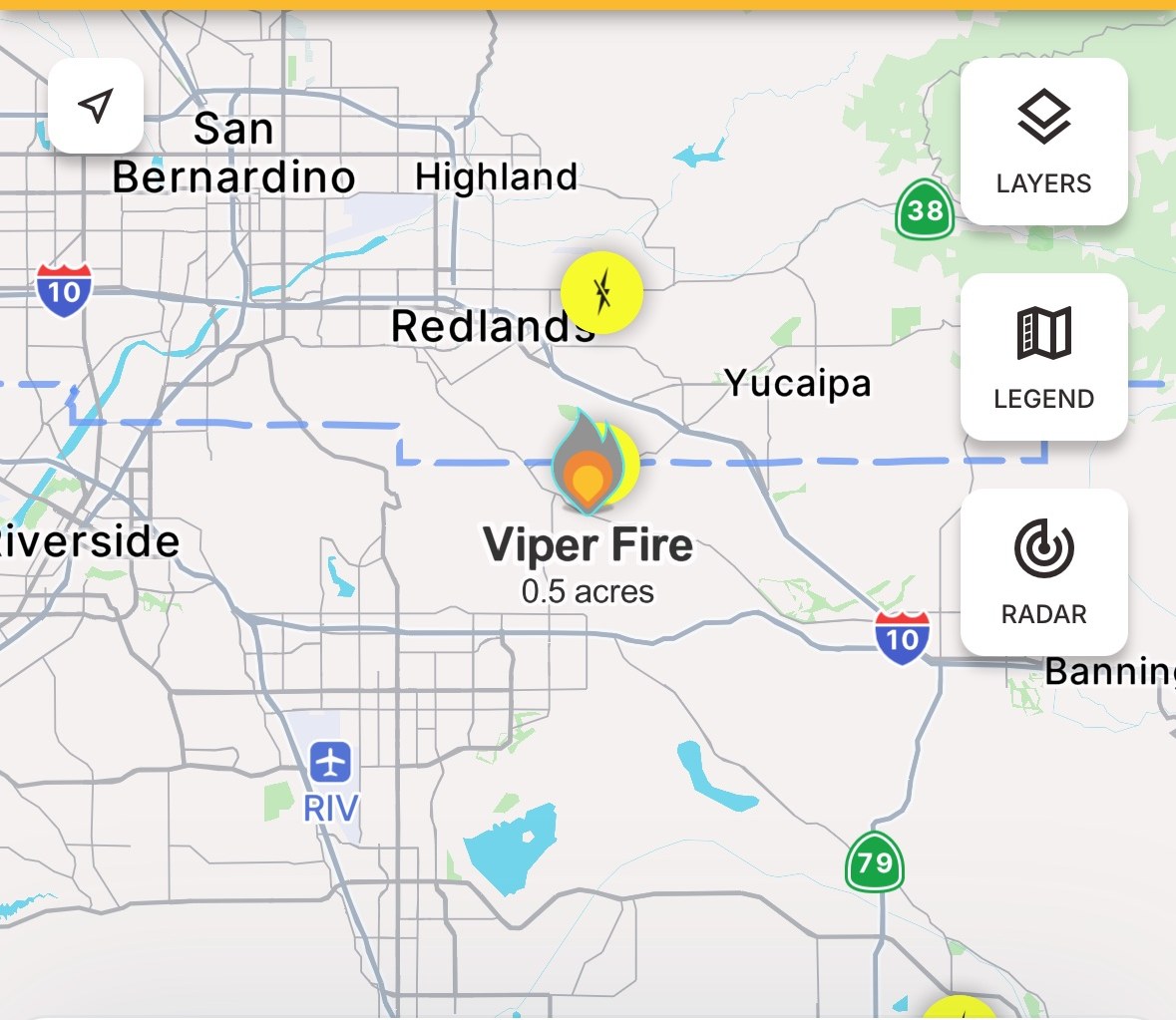
河滨县——加州河滨县 San Timoteo Canyon 一带的野火「Viper Fire」蔓延已被遏止。据加州消防局(CAL FIRE)事故通报,这场火过火面积为 0.5 英亩,消防员在 10 月 19 日(周一)下午约 4 时 10 分的更新中确认火势前进蔓延已被阻止(Forward Progress Stopped),队伍将留守现场数小时,沿火场周边铺设水带、清理余火。
本台此前报道,这场火于当天下午 3 时 24 分被报告,联邦跨机构事故系统(IRWIN)随即立项,由 CAL FIRE 河滨分局(河滨县消防局)主管处置。CAL FIRE 事故页把起火地点列为 San Timoteo Canyon Road 与 Live Oak Canyon Road 一带、Yucaipa 西南侧;该处地处河滨县与圣贝纳迪诺县交界,Watch Duty 的地址标注为 San Timoteo Canyon Rd at Redlands Blvd, Redlands。参与处置的单位包括 CAL FIRE 河滨分局与圣贝纳迪诺分局、Redlands 消防局和圣贝纳迪诺县消防局,最初投入多辆消防车、地面队伍及一架直升机。
面积方面,CAL FIRE 官方数字与 Watch Duty 16 时 27 分的标注一致,均为 0.5 英亩;IRWIN 系统早前登记的 0.25 英亩为初期估算。截至最新通报,这场火未造成人员伤亡,也无建筑受损或受威胁的报告,未发布疏散令或疏散警告;CAL FIRE 尚未公布控制率百分比,起火原因仍在调查中。
Update: Forward Progress of Riverside County Viper Fire Stopped at 0.5 Acres; Crews Staying for Mop-Up
RIVERSIDE COUNTY — Forward progress of the Viper Fire, a brush fire burning along San Timoteo Canyon in Riverside County, California, has been stopped. According to the CAL FIRE incident page, the fire has burned 0.5 acres, and an update at about 4:10 p.m. on Monday, October 19 confirmed that forward progress had been stopped; firefighters will remain on scene for several hours building hose lays around the fire and mopping up hot spots.
As GSM reported earlier, the fire was first reported at 3:24 p.m. the same day and logged in the federal Interagency Initial Attack system (IRWIN), with CAL FIRE's Riverside Unit (Riverside County Fire Department) as the protecting agency. CAL FIRE lists the location as San Timoteo Canyon Road and Live Oak Canyon Road, southwest of Yucaipa; the spot sits on the Riverside–San Bernardino county line, and Watch Duty geocodes the address as San Timoteo Canyon Rd at Redlands Blvd, Redlands. Cooperating agencies include CAL FIRE's Riverside and San Bernardino units, the Redlands Fire Department and San Bernardino County Fire, which initially sent multiple engines, crews and one helicopter.
On size, CAL FIRE's official figure matches Watch Duty's 4:27 p.m. reading of 0.5 acres; the 0.25 acres initially logged in IRWIN was an early estimate. As of the latest update there are no injuries and no structures damaged or threatened, no evacuation orders or warnings have been issued, CAL FIRE has not yet posted a containment percentage, and the cause remains under investigation.
发布:GSM·美国(发布链接)
图片来源:图:Viper Fire 最新态势图,Watch Duty 截图(美西时间10月19日16时27分截取)。火点位于 Redlands 以南、San Timoteo Canyon 一带,地处河滨县与圣贝纳迪诺县交界;Watch Duty 显示过火 0.5 英亩、蔓延已遏止。图片来源:Watch Duty。Latest situation map of the Viper Fire, Watch Duty screenshot taken at 4:27 p.m. PDT on Oct. 19. The fire sits south of Redlands along San Timoteo Canyon, on the Riverside–San Bernardino county line; Watch Duty shows 0.5 acres with forward progress stopped. Image: Watch Duty.
GSM Global · 本篇英文版 English edition of this story
- 2026-10-19 15:58河滨县Moreno Valley以北爆发「Viper Fire」 CAL FIRE处置 面积与控制率待官方公布
- 2026-10-19 16:31跟进:河滨县「Viper Fire」蔓延已遏止 过火0.5英亩 消防员留守清理余火本篇