本季最冷空气席卷美国中北部与东部:多地冻害警告生效 五大湖区迎本季初雪
据 TheWeather.com 综合国家气象局信息报道,一股异常强的高压系统本周末把本季以来最冷的空气带给数以百万计的居民。强冷锋已于周五前后扫出东海岸,冷空气先影响平原、上中西部与五大湖区,再向东扩散至俄亥俄河谷、田纳西河谷、阿巴拉契亚地区与大西洋中部各州,一直持续到周六夜间。
平原、上中西部与五大湖区的广大地区已发布冻害警告(Freeze Warnings)与霜冻提示(Frost Advisories),气温骤降并伴有阵性西北风,体感温度更具冬日感。气象部门指出,这轮广泛的霜冻与冰点气温可能使许多社区的生长季就此结束,敏感植物、花园与晚季作物面临冻害风险。
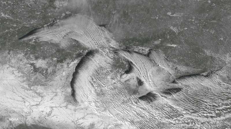
AccuWeather 指出,来自加拿大的冷空气在上周后段至本周末先后扫过五大湖区、新英格兰、阿巴拉契亚北部与大西洋中部,抹去了此前部分地区接近纪录的高温;周六预计成为今年年初以来最冷的一天。周六清晨,内陆地区的体感温度(RealFeel)降至华氏20多度至30多度,I-95走廊沿线也在30多度至40多度;阿巴拉契亚北部白天最高气温只有30多度至40多度。冷空气掠过五大湖时还带来湖效应降雪,部分地区甚至可能出现雷雪;五大湖区北部与东北部内陆部分地区迎来本季初雪,从宾夕法尼亚州中北部到纽约州西部、中部与北部、再到新英格兰西北部的高地势地区均有阵雪。
(GSM 据 TheWeather.com、AccuWeather 经 Men's Journal 报道)
Season's Coldest Air Sweeps the North-Central and Eastern U.S.: Freeze Warnings in Effect as the Great Lakes Region Sees Its First Snow
An unusually strong area of high pressure brought the coldest air of the season so far to millions of residents this weekend, TheWeather.com reported, drawing on National Weather Service information. A strong cold front exited the East Coast late in the week, and the cold air initially affected the Plains, the Upper Midwest and the Great Lakes before spreading eastward into the Ohio and Tennessee Valleys, the Appalachians and the Mid-Atlantic through Saturday night.
Freeze Warnings and Frost Advisories were in effect across large portions of the Plains, Upper Midwest and Great Lakes, with temperatures dropping sharply and gusty northwest winds making conditions feel even more wintry. Forecasters said the combination of widespread frost and freezing temperatures could bring an end to the growing season for many communities, leaving sensitive plants, gardens and late-season crops vulnerable.
AccuWeather reported that cold air from Canada swept into the Great Lakes, New England, the northern Appalachians and the mid-Atlantic to end the week and start the weekend, erasing near-record heat in some areas, and that Saturday was expected to be the coldest day since early in 2026. RealFeel temperatures on Saturday morning dipped into the 20s and 30s across the interior and hovered in the 30s to lower 40s along much of the Interstate 95 corridor, while actual highs were in the 30s and 40s over the northern Appalachians. As the cold air passed over the Great Lakes it produced lake-effect snow showers, with a possibility of thundersnow; parts of the northern Great Lakes and the interior Northeast saw the first snow of the season, with snow showers across higher terrain from north-central Pennsylvania to western, central and northern New York and northwestern New England.
(GSM via TheWeather.com and AccuWeather via Men's Journal)
发布:GSM·美国(发布链接)
图片来源:Wikimedia Commons 文件 File:Lake effect snow bands over the Great Lakes region (2268-643).jpg,作者 NOAA,Public domain。图为五大湖区湖效应降雪带卫星云图。
GSM Global · 本篇英文版 English edition of this story