跟进:北加州Mendocino县「Cooley Fire」重测过火面积1,036英亩 控制率升至15%
Mendocino县——据加州消防局(CAL FIRE)官方事故页10月18日的更新,北加州Mendocino县Cloverdale以西的野火「Cooley Fire」控制率已升至15%,过火面积经重新测绘定为1,036英亩。事故页页眉现显示过火面积1,037英亩、控制率15%,页面最后更新时间为10月18日下午3时59分;与17日晚公布的731英亩、控制率5%相比,面积增加约305英亩、控制率提高10个百分点。
当天更新的时间线:清晨6时59分,CAL FIRE通报消防员彻夜扑救,夜间飞行直升机支援战略性烧除作业,更多扑救资源当天陆续抵达并部署到火线,但地形陡峭崎岖、道路进入有限,仍给扑救带来困难;上午11时10分,官方通报消防员夜间在火场东北角实施了烧除作业——趁夜间气温较低、湿度上升、风力减弱,提前烧掉火头前方的未燃植被以切断燃料,当时过火面积仍为731英亩、控制率5%;中午12时37分,官方通报这场火经测绘定为1,036英亩;下午3时57分,官方通报控制率升至15%。
这场火于10月16日下午5时05分在Elkhorn Road与Cooley Ranch Road一带燃起,由CAL FIRE门多西诺分队(Mendocino Unit)管辖,目前未设事故管理团队,起火原因仍在调查中。据《新闻民主报》(Press Democrat)此前报道,这场火源于面积约19,000英亩的Cooley Ranch牧场内一次私人计划烧除失控越界,该烧除并非CAL FIRE实施的项目。官方本轮更新未提及新的疏散令、建筑损毁或人员伤亡;这场火此前一直没有疏散令或疏散警告发布。烟尘方面,湾区空气质量管理局(BAAQMD)10月17日曾对Sonoma县北部发布空气质量提示,当地监测点一度录得「非常不健康」级别的空气质量指数。
回看这场火前两天的官方进程:16日晚7时50分过火40英亩;17日上午11时10分一度报至1,000英亩,中午12时33分经更精确测绘修订为558英亩,下午1时14分通报控制率5%,下午5时11分过火面积升至731英亩;至18日,经再次测绘定为1,036英亩、控制率升至15%。
Follow-Up: Cooley Fire in Mendocino County Remapped at 1,036 Acres, Containment Rises to 15%
MENDOCINO COUNTY — Containment of the Cooley Fire, burning west of Cloverdale in Mendocino County, has risen to 15% and its size has been remapped at 1,036 acres, according to updates posted on CAL FIRE's official incident page on Sunday, October 18. The page header now shows 1,037 acres and 15% containment, with the page last updated at 3:59 p.m. on October 18 — against 731 acres and 5% containment reported on the evening of October 17, an increase of about 305 acres and 10 points of containment.
The day's updates in sequence: at 6:59 a.m., CAL FIRE said firefighters had worked overnight with night-flying helicopters supporting strategic firing operations, that additional resources would keep arriving and deploying to the fireline, and that steep, rugged terrain and limited road access were still hampering the effort. At 11:10 a.m., officials reported an overnight firing operation in the fire's northeast corner — burning out unburned vegetation ahead of the fire at night, when cooler temperatures, higher humidity and lighter winds lower flame intensity and reduce the risk of embers crossing control lines — and said the fire remained at 731 acres and 5% contained at that point. At 12:37 p.m., the fire was mapped at 1,036 acres; at 3:57 p.m., containment was reported at 15%.
The fire began at 5:05 p.m. on October 16 near Elkhorn Road and Cooley Ranch Road, is under the jurisdiction of the CAL FIRE Mendocino Unit with no incident management team assigned, and its cause remains under investigation. The Press Democrat has reported that the fire began as a private prescribed burn on the roughly 19,000-acre Cooley Ranch that escaped its boundaries, and that the burn was not a CAL FIRE project. Sunday's official updates mentioned no new evacuation orders, structure damage or injuries, and no evacuation orders or warnings have been issued for this fire at any point. On smoke, the Bay Area Air Quality Management District issued an air quality advisory for northern Sonoma County on October 17, when monitors there recorded air quality index readings in the 'very unhealthy' range.
The fire's first two days, by the official updates: it stood at 40 acres by 7:50 p.m. on October 16; on October 17 it was reported at 1,000 acres at 11:10 a.m., revised down to 558 acres at 12:33 p.m. after more accurate mapping, reached 5% containment at 1:14 p.m., and grew to 731 acres by 5:11 p.m. Sunday's remapping put it at 1,036 acres with containment at 15%.
来源:GSM·美国(原文链接)
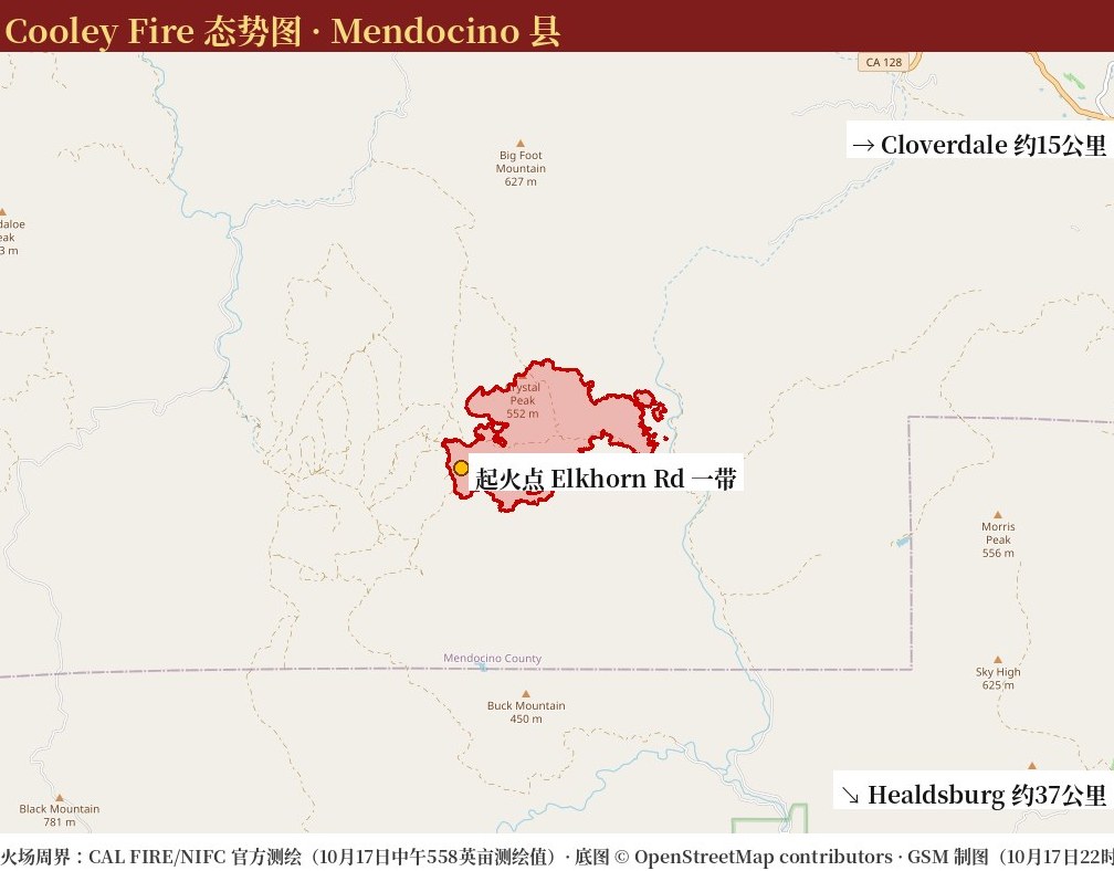
图片来源:图:Cooley Fire 态势图(GSM 据 CAL FIRE/NIFC 官方测绘周界绘制,10月17日,本轮重新裁切)。图中红色周界为17日中午官方测绘的火场范围(558英亩测绘值);最新官方数据以正文为准:加州消防局(CAL FIRE)10月18日中午12时37分重测过火面积为1,036英亩(事故页页眉显示1,037英亩)、下午3时57分通报控制率升至15%。底图 © OpenStreetMap contributors。Situation map of the Cooley Fire, drawn by GSM from the official CAL FIRE/NIFC mapped perimeter as of midday Oct. 17 (558 mapped acres; re-cropped for this update). The latest official figures are in the text: CAL FIRE remapped the fire at 1,036 acres at 12:37 p.m. on Oct. 18 (the incident page header shows 1,037 acres) and reported 15% containment at 3:57 p.m. Base map © OpenStreetMap contributors.
- 2026-10-17 22:42北加州Mendocino县Cooley Fire过火面积升至731英亩 控制率仅5% 暂无疏散令
- 2026-10-18 16:24跟进:北加州Mendocino县「Cooley Fire」重测过火面积1,036英亩 控制率升至15%本篇
- 2026-10-18 22:49跟进:北加州Mendocino县「Cooley Fire」过火面积升至1,156英亩 控制率15%
- 2026-10-19 08:30跟进:北加州Mendocino县「Cooley Fire」控制率升至23% 过火面积仍为1,156英亩
- 2026-10-19 14:50跟进:北加州Mendocino县「Cooley Fire」过火面积升至1,364英亩 控制率仍为23%
- 2026-10-19 18:10跟进:北加州Mendocino县「Cooley Fire」控制率升至45% 过火面积1,364英亩
- 2026-10-20 01:14跟进:Mendocino县「Cooley Fire」开始火场修护 内部未燃区未见明火、建筑无损
- 2026-10-20 15:47跟进:北加州Mendocino县「Cooley Fire」控制率升至57% 过火面积1,365英亩
- 2026-10-20 18:01跟进:北加州Mendocino县「Cooley Fire」控制率升至67% 过火面积1,365英亩 队伍开始回收火线装备
- 2026-10-23 00:21跟进:北加州Mendocino县「Cooley Fire」控制率升至80% 过火面积1,365英亩 指挥权移交本地分队