加州Calimesa附近Shore Fire山火最终烧毁3,085英亩,疏散令逐步解除、无人受伤
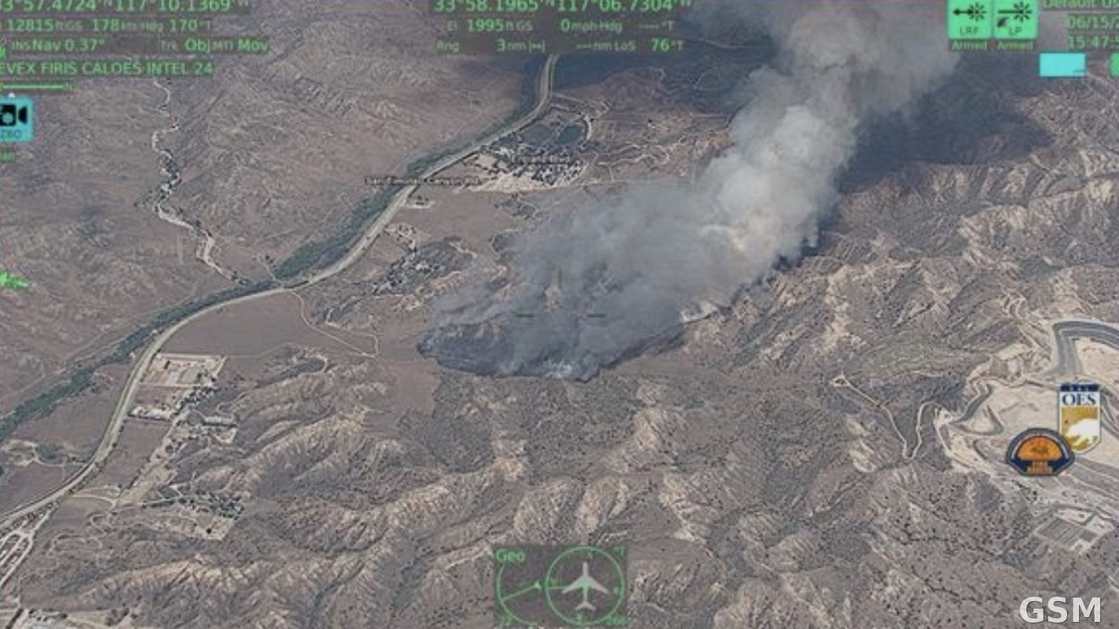
2026年6月15日,美国加利福尼亚州河滨县 Calimesa 西南的 San Timoteo Canyon 一带发生山火 Shore Fire。加州林业与消防局(CAL FIRE)当晚11时08分通报,火场为92英亩;这是河滨县当月一起快速扩大的灌木山火。
火势在夜间迅速蔓延:6月16日凌晨1时21分,火场扩至500英亩,当局发出疏散令与疏散警告;同日上午,火场达2,053英亩、受控20%。60号高速公路西行方向在10号州际公路交汇处一度关闭,6月16日下午已重新开放,当局提醒驾驶人避开烟雾影响路段、注意进出火场的消防车辆与重型设备。
经连日扑救,火场最终测绘为3,085英亩。6月17日晚,RVC-231-B、RVC-231-C 等分区的疏散令降级为警告;6月18日晚,火场周边分区的疏散令同样降级为警告,其余警告陆续取消。CAL FIRE 在6月17日与19日的更新中均表示,本次山火无人受伤。
消防人员其后继续加强控制线、清理火场内热点并开展扑救修复作业,至6月20日火场受控达95%。
Shore Fire Near Calimesa, California, Burns 3,085 Acres Before Containment; Evacuation Orders Lifted in Stages, No Injuries
The Shore Fire broke out on June 15, 2026, in the San Timoteo Canyon area southwest of Calimesa in Riverside County, California. CAL FIRE reported at 11:08 p.m. that evening that the fire stood at 92 acres; it became a fast-growing brush fire in Riverside County that month.
The fire spread quickly overnight. By 1:21 a.m. on June 16 it had grown to 500 acres, and evacuation orders and warnings were issued. By that morning it had reached 2,053 acres and was 20 percent contained. Westbound Highway 60 at the Interstate 10 interchange was closed for a time and reopened on the afternoon of June 16; motorists were urged to use caution amid drift smoke and to watch for firefighters, heavy equipment and emergency vehicles entering and leaving the incident.
After days of firefighting, the fire was finally mapped at 3,085 acres. On the evening of June 17, evacuation orders for zones including RVC-231-B and RVC-231-C were downgraded to warnings, and on the evening of June 18 the evacuation order for the fire perimeter zone was likewise downgraded to a warning while other warnings were canceled. CAL FIRE stated in its June 17 and June 19 updates that no injuries had been reported in the fire.
Crews then continued strengthening containment lines, extinguishing interior hotspots and carrying out suppression repair, and by June 20 the fire was 95 percent contained.
来源:加州林业与消防局
发布:GSM·美国(发布链接)
图片来源:图:2026年6月15日,空中情报飞机拍摄的加州河滨县 Shore Fire 火场与烟柱(本事件官方航拍图,画面为 FIRIS 情报叠加层)。加州林业与消防局(CAL FIRE)/加州州长紧急服务办公室发布。 / Photo: The Shore Fire in Riverside County, California, and its smoke column, photographed from an intelligence aircraft on June 15, 2026 (official aerial image of this incident, with FIRIS intelligence overlay). Released by CAL FIRE and the California Governor's Office of Emergency Services.
GSM Global · 本篇英文版 English edition of this story