飓风西蒙今晨预计在哈利斯科州登陆:155英里时速逼近曼萨尼约,22市镇停课疏散
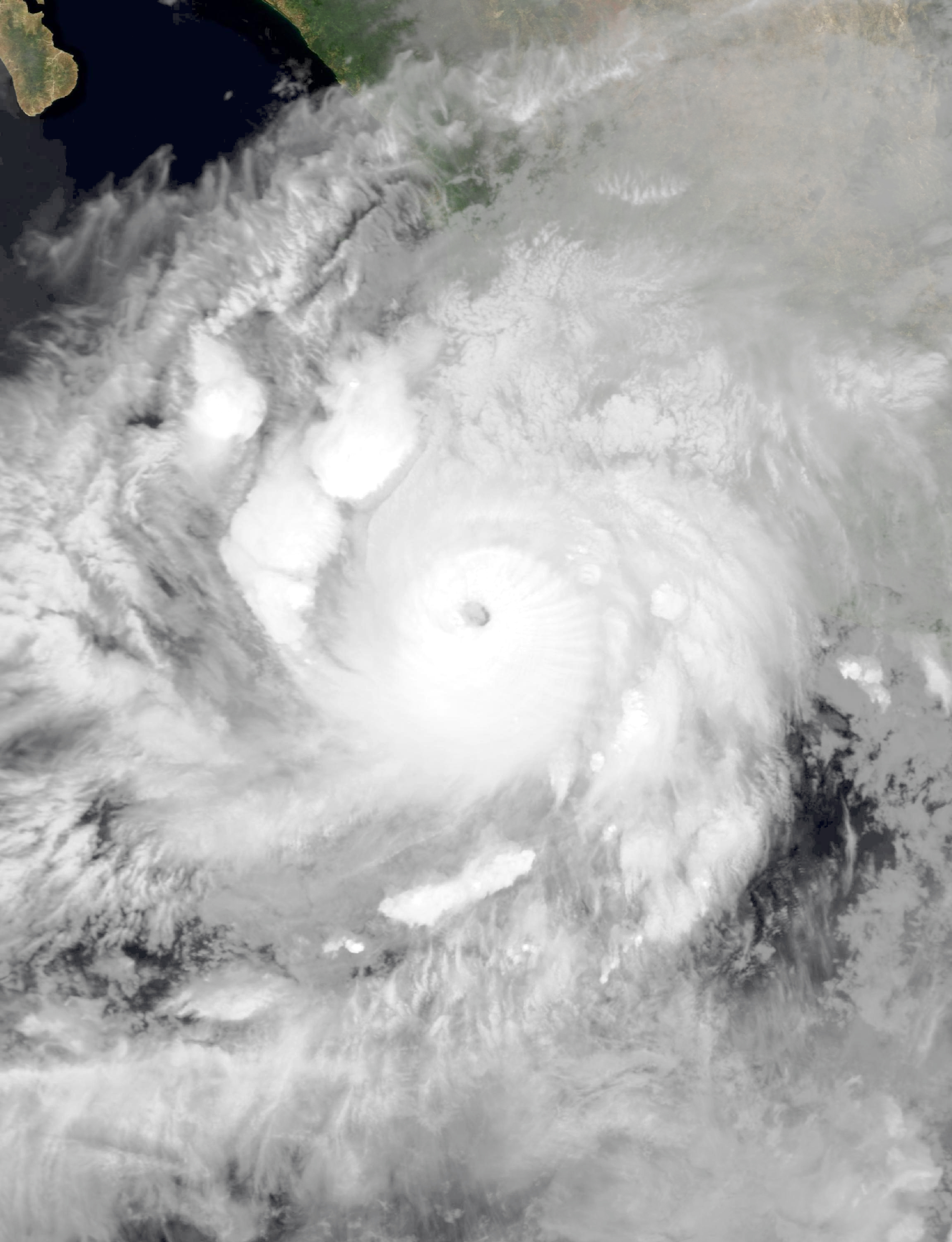
飓风"西蒙"(Simon)正在逼近墨西哥太平洋沿岸,预计周日清晨登陆。据美国国家飓风中心(NHC)周日凌晨(中部时间)发布的公告,"西蒙"最大持续风速达155英里/小时(约250公里/小时),中心最低气压928毫巴,为四级飓风;其中心位于曼萨尼约西南约60英里处,以每小时5英里的速度向北移动。截至该份公告发布时,"西蒙"尚未登陆。
NHC预计,"西蒙"将于周日清晨在哈利斯科州拉韦尔塔(La Huerta)至托马特兰(Tomatlán)一带登陆或擦过海岸(据Particle新闻引述NHC预报)。气象网站weather.com报道,"西蒙"将以四级强度袭击哈利斯科州,风暴中心当天晚些时候还将经过巴亚尔塔港附近——这可能是自2023年10月飓风"莉迪亚"以来袭击巴亚尔塔港的最强风暴。NHC警告,灾难性强风与危及生命的风暴潮可能出现在墨西哥中西部部分海岸。
警报方面,飓风警报覆盖从蓬塔圣特尔莫(Punta San Telmo)至埃尔罗布利托(El Roblito)的海岸线及拉斯伊斯拉斯马里亚斯群岛;蓬塔圣特尔莫以东至拉萨罗卡德纳斯一带则发布了热带风暴观察。
墨西哥地方政府已全面戒备。据美联社报道,哈利斯科州22个沿海市镇停课并开始疏散脆弱地区居民;联邦政府启动海军"Plan Marina"应急预案,多港口关闭或限制船只通行。据Particle新闻报道,海事救援队已把约80名居民和9只宠物从耶拉帕(Yelapa)、基米克斯托(Quimixto)等沿海村落预防性转移至临时避难所。
降雨是另一大威胁。NHC预计,10至20英寸(25至50厘米)的降雨将覆盖墨西哥西南部,米却肯州、科利马州和哈利斯科州局部可达30英寸(76厘米),可能引发危及生命的山洪与泥石流,尤其是在陡峭地形地区。登陆点附近及以东海岸还将出现风暴潮与破坏性大浪,沿海地区不排除出现龙卷风。
GSM此前报道,"西蒙"周六已增强为四级飓风。NHC提醒,飓风警报区内居民应立即完成防灾准备,听从当地应急部门指引。(来源:美国国家飓风中心、美联社、weather.com)
Hurricane Simon Nears Landfall in Jalisco: 155-mph Category 4 Storm Approaches Manzanillo, 22 Municipalities Suspend Classes
Hurricane Simon is closing in on Mexico's Pacific coast and is expected to make landfall Sunday morning. According to the U.S. National Hurricane Center (NHC) advisory issued early Sunday (Central Time), Simon packed maximum sustained winds of 155 mph (about 250 km/h) with a minimum central pressure of 928 millibars, a Category 4 hurricane; its center was about 60 miles southwest of Manzanillo, moving north at 5 mph. As of that advisory, Simon had not made landfall.
The NHC expects Simon to make landfall or skirt the coast Sunday morning between La Huerta and Tomatlán in the state of Jalisco (per Particle News citing the NHC forecast). Weather.com reports Simon will strike Jalisco at Category 4 intensity, with the storm's core passing near Puerto Vallarta later in the day — potentially the strongest storm to hit Puerto Vallarta since Hurricane Lidia in October 2023. The NHC warns that catastrophic winds and life-threatening storm surge are possible along parts of Mexico's west-central coast.
A hurricane warning covers the coast from Punta San Telmo to El Roblito, including the Islas Marías archipelago; a tropical storm watch is in effect from east of Punta San Telmo to Lázaro Cárdenas.
Mexican authorities are on full alert. The Associated Press reports that the state of Jalisco suspended classes in 22 coastal municipalities and began evacuating vulnerable areas; the federal government activated the Navy's Plan Marina emergency protocol, closing or restricting navigation at multiple ports. Particle News reports maritime rescue teams preventively moved about 80 residents and nine pets from coastal villages including Yelapa and Quimixto to temporary shelters.
Rainfall is another major threat. The NHC forecasts 10 to 20 inches (25 to 50 cm) across southwestern Mexico, with isolated totals up to 30 inches (76 cm) in Michoacán, Colima and Jalisco, capable of producing life-threatening flash flooding and mudslides, especially in steep terrain. Storm surge and large destructive waves are expected near and east of the landfall point, and tornadoes are possible along the coast.
GSM previously reported that Simon strengthened to Category 4 on Saturday. The NHC urges residents in the hurricane warning area to complete protective preparations immediately and follow local emergency instructions. (Sources: U.S. National Hurricane Center, Associated Press, weather.com)
图片来源:飓风西蒙10月10日卫星云图,公有领域 / NASA Aqua MODIS(Wikimedia Commons)